

Gate of the Lions entrance to Hattusa, the capital of the Hittite Empire in the late Bronze Age, Boğazkale, Turkey / Photo by Carole Raddato, Wikimedia Commons

Edited by Matthew A. McIntosh / 02.14.2018
Historian
Brewminate Editor-in-Chief
1 – Ancient Societies on the Mediterranean
1.1 – The Hittites
The Hittites were an ancient Anatolian people of the Bronze Age, who manufactured advanced iron goods, ruled through government officials with independent authority over various branches of government, and worshipped storm gods.
1.1.1 – Overview
The Hittites were an ancient Anatolian people who established an empire at Hattusa in north-central Anatolia around 1600 BCE. The Hittite Empire reached its height during the mid-14th century BCE under Suppiluliuma I, when it encompassed an area that included most of Asia Minor as well as parts of the northern Levant and Upper Mesopotamia. After c. 1180 BCE, the empire came to an end during the Bronze Age collapse, and splintered into several independent “Neo-Hittite” city-states, some of which survived until the 8th century BCE.
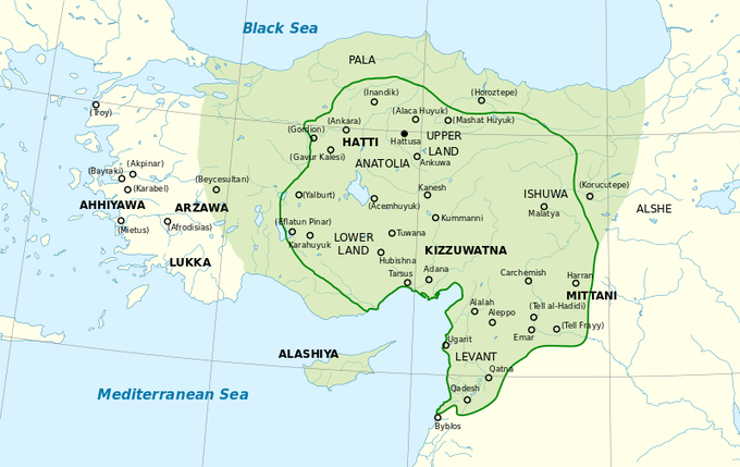
The Hittite Empire at its greatest extent under Suppiluliuma I (c. 1350–1322 BCE) and Mursili II (c. 1321–1295 BCE):The approximate extent of the maximum area of the Hittite rule (light green) and the Hittite rule c. 1350-1300 BCE (green line).
The Hittite language was a member of the Anatolian branch of the Indo-European language family. They referred to their native land as Hatti. The conventional name “Hittites” is due to their initial identification with the Biblical Hittites, according to 19th century archaeology. The Hebrew Bible refers to “Hittites” in several passages, and links them to an eponymous ancestor Heth, a descendant of Ham through his son Canaan. The Hittites are thereby counted among the Canaanites. The Hittites are usually depicted as a people living among the Israelites—Abraham purchases the Patriarchal burial-plot from “Ephron HaChiti” (Ephron the Hittite), and Hittites serve as high military officers in David’s army. In 2 Kings 7:6, they are depicted as a people with their own kingdoms.
Despite the use of Hatti as the core of their territory, the Hittites should be distinguished from the Hattians, an earlier people who inhabited the same region (until the beginning of the 2nd millennium BCE), and spoke a different language, possibly in the Northwest Caucasian language group known as Hattic.
The Hittite military made successful use of chariots. Although their civilization thrived during the Bronze Age, the Hittites were the forerunners of the Iron Age and were manufacturing iron artifacts from as early as the 14th century BCE. Correspondence with rulers from other empires reveal a foreign demand for iron goods.
After 1180 BCE, amid general turmoil in the Levant associated with the sudden arrival of the Sea Peoples, the kingdom disintegrated into several independent “Neo-Hittite” city-states. The history of the Hittite civilization is known mostly from cuneiform texts found in the area of their kingdom, and from diplomatic and commercial correspondence found in various archives in Egypt and the Middle East.
1.1.2 – Culture
Government
The head of the Hittite state was the king, followed by the heir-apparent. However, some officials exercised independent authority over various branches of the government. One of the most important of these posts was that of the Gal Mesedi (Chief of the Royal Bodyguards). It was superseded by the rank of the Gal Gestin (Chief of the Wine Stewards), who, like the Gal Mesedi, was generally a member of the royal family. The kingdom’s bureaucracy was headed by the Gal Dubsar (Chief of the Scribes).
Religion
Hittite religion and mythology were heavily influenced by their Hattic, Mesopotamian, and Hurrian counterparts. In earlier times, Indo-European elements may still be clearly discerned.
“Storm gods” were prominent in the Hittite pantheon. Tarhunt was referred to as “The Conqueror,” “The King of Kummiya,” “King of Heaven,” and “Lord of the land of Hatti.” As the god of battle and victory, especially against foreign powers, he was chief among the gods and was depicted as a bearded man astride two mountains and bearing a club.
1.2 – The Phoenicians
Known for their alphabet, the Phoenicians were an ancient Semitic maritime trading culture in the Mediterranean. They fell under both Persian and Hellenistic rule.
1.2.1 – Overview
Phoenicia was an ancient Semitic civilization situated on the western, coastal part of the Fertile Crescent near modern-day Lebanon, Israel, Jordan, Palestine, and Syria. All major Phoenician cities were on the coastline of the Mediterranean. It was an enterprising maritime trading culture that spread across the Mediterranean from 1550 BCE to 300 BCE. The Phoenicians used the galley, a man-powered sailing vessel, and are credited with the invention of the bireme oared ship. They were famed in Classical Greece and Rome as “traders in purple,” which refers to their monopoly on the precious purple dye of the Murex snail, used for royal clothing, among other things.
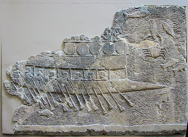
Assyrian Warship: Assyrian warship (probably built by Phoenicians) with two rows of oars, relief from Nineveh, c. 700 BCE.
Phoenician became one of the most widely used writing systems. It was spread by Phoenician merchants across the Mediterranean world, where it evolved and was assimilated by many other cultures. The Aramaic alphabet, a modified form of Phoenician, was the ancestor of modern Arabic script, while Hebrew script is a stylistic variant of the Aramaic script. The Greek alphabet (and by extension its descendants, such as the Latin, the Cyrillic, and the Coptic) was a direct successor of Phoenician, though certain letter values were changed to represent vowels.
Phoenicians are widely thought to have originated from the earlier Canaanite inhabitants of the region. Although Egyptian seafaring expeditions had already been made to Byblos to bring back “cedars of Lebanon” as early as the 3rd millennium BCE, continuous contact only occurred in the Egyptian New Empire period.
It is important to note that Phoenicia is a Classical Greek term used to refer to the region of the major Canaanite port towns, and does not correspond exactly to a cultural identity that would have been recognized by the Phoenicians themselves. It is uncertain to what extent the Phoenicians viewed themselves as a single ethnicity and nationality. Their civilization was organized in city-states, similar to that of ancient Greece. However, in terms of archaeology, language, life style and religion, there is little to set the Phoenicians apart as markedly different from other Semitic cultures of Canaan. As Canaanites, they were unique in their remarkable seafaring achievements.

Phoenician Sarcophagus: A Phoenician sarcophagus at the burial grounds of Antarados, northern Lebanon, 480-450 BCE. Made from Greek marble.
Each Phoenician city-state was a politically independent unit. City-states often came into conflict with one another, with the result that one may dominate another. City-states were also inclined to collaborate in leagues and alliances. Though ancient boundaries of city-centered cultures fluctuated, the city of Tyre held the southernmost border of Phoenician territory.
1.2.2 – Rise and Decline
The high point of Phoenician culture and sea power is usually placed c. 1200-800 BCE, though many of the most important Phoenician settlements had been established long before this period. Archeology has identified cultural elements of the Phoenician zenith as early as the 3rd millennium BCE. The league of independent city-state ports, with others on the islands and along other coasts of the Mediterranean Sea, was ideally suited for trade between the Levant area (which was rich in natural resources) and the rest of the ancient world. During the early Iron Age, around 1200 BCE, Sea Peoples appeared in the area from the north, which weakened and destroyed the Egyptians and Hittites, respectively. In the resulting power vacuum, a number of Phoenician cities rose as significant maritime powers.
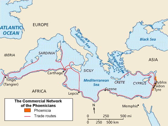
Phoenician Trade Network: Map of Phoenicia and its trade routes.
These societies rested on three power-bases: the king; the temple and its priests; and the councils of elders. Byblos first became the predominant center from where the Phoenicians dominated the Mediterranean and Erythraean (Red) Sea routes. It was here that the first inscription in the Phoenician alphabet was found, on the sarcophagus of Ahiram (c. 1200 BCE). Tyre rose to power several hundred years later. One of its kings, the priest Ithobaal (887–856 BCE), ruled Phoenicia as far north as Beirut and Cyprus. Carthage was founded in 814 BCE, under Pygmalion of Tyre (820–774 BCE). The collection of city-states constituting Phoenicia came to be characterized by outsiders and the Phoenicians as Sidonia or Tyria. Phoenicians and Canaanites alike were called Sidonians or Tyrians, as one Phoenician city came to prominence after another.
1.2.3 – Persian Rule
Cyrus the Great of Persia conquered Phoenicia in 539 BCE. The Persians divided Phoenicia into four vassal kingdoms: Sidon, Tyre, Arwad, and Byblos. Though these vassal kingdoms prospered and furnished fleets for the Persian kings, Phoenician influence declined after this period. It is likely that much of the Phoenician population migrated to Carthage and other colonies following the Persian conquest. In 350 or 345 BCE, a rebellion in Sidon was crushed by Artaxerxes III.
1.2.4 – Hellenistic Rule
Alexander the Great took Tyre in 332 BCE after the Siege of Tyre, and kept the existing king in power. He gained control of the other Phoenician cities peacefully, and the rise of Hellenistic Greece gradually ousted the remnants of Phoenicia’s former dominance over the Eastern Mediterranean trade routes. Phoenician culture disappeared entirely in the motherland. Carthage continued to flourish in North Africa. It oversaw the mining of iron and precious metals from Iberia, and used its considerable naval power and mercenary armies to protect commercial interests. It was finally destroyed by Rome in 146 BC, at the end of the Punic Wars.
1.3 – The Minoans
The Minoans were an Aegean Bronze Age civilization on the island of Crete that flourished between 2800-1450 BCE. They left behind extensive material culture showing the extent of their handicraft and influence upon Mycenaean culture.
1.3.1 – Overview
The Minoan civilization was an Aegean Bronze Age civilization that arose on the island of Crete, and flourished from approximately the 27th century to the 15th century BCE.
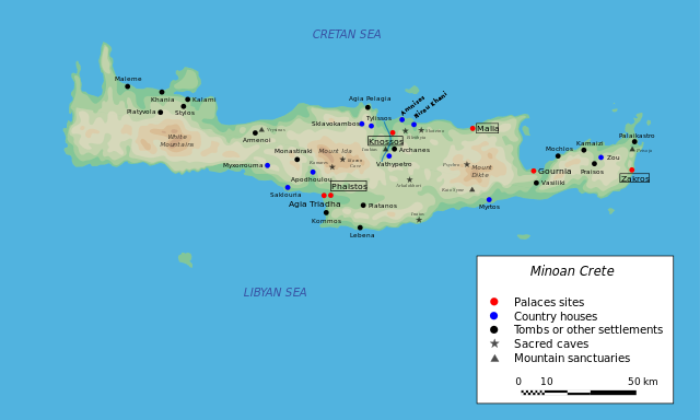
Minoan Crete: A map of Minoan Crete.
The early inhabitants of Crete settled as early as 128,000 BCE, during the Middle Paleolithic Age. It was not until 5000 BCE that the first signs of advanced agriculture appeared, marking the beginning of civilization. The term “Minoan” was coined by Arthur Evans after the mythic “king” Minos. Minos was associated in Greek myth with the labyrinth, which is identified with the site at Knossos.
The Bronze Age began in Crete around 2700 BCE, when several localities on the island developed into centers of commerce and handwork. This development enabled the upper classes to continuously practice leadership activities and to expand their influence. It is likely that the original hierarchies of the local elites were replaced by monarchist power structures— a precondition for the creation of the great palaces.
Around 1700 BCE, there was a large disturbance in Crete, possibly an earthquake or an invasion from Anatolia. The palaces at Knossos, Phaistos, Malia, and Kato Zakros were destroyed. But with the start of the Neopalatial period (the 17th and 16th centuries BCE), population increased again, palaces were rebuilt on a larger scale, and new settlements sprung up all over the island. This period represents the apex of the Minoan civilization.
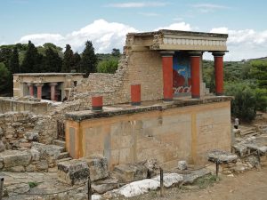
Knossos – North Portico: Restored North Entrance of the Knossos palace complex, with the charging bull fresco.
The influence of the Minoan civilization outside Crete has been seen in the evidence of valuable Minoan handicraft items on the Greek mainland. It is likely that the ruling house of Mycene was connected to the Minoan trade network. After c. 1700 BCE, the material culture on the Greek mainland achieved a new level due to Minoan influence. Connections between Egypt and Crete are also prominent. Minoan ceramics are found in Egyptian cities, and the Minoans imported several items from Egypt, especially papyrus, as well as architectural and artistic ideas. The Egyptian hieroglyphs served as a model for Minoan pictographic writing, from which the famous Linear A and Linear B writing systems later developed. There has also been evidence of Minoan influence among Canaanite artifacts.
The Minoan culture began to decline c. 1450 BCE, following an earthquake, the eruption of the Thera volcano, or another possible natural catastrophe. Several important palaces in locations such as Mallia, Tylissos, Phaistos, Hagia Triade, as well as the living quarters of Knossos were destroyed, but the palace in Knossos seems to have remained largely intact. The preservation of this palace resulted in the Dynasty in Knossos spreading its influence over large parts of Crete until it was overrun by Mycenaean Greeks.
1.3.2 – Society and Culture
Pottery
The best surviving examples of Minoan art are its pottery and palace architecture with frescos that include landscapes, stone carvings, and intricately carved seal stones. Ceramics from the Early Minoan period are characterized by linear patterns of spirals, triangles, curved lines, crosses, and fishbone motifs. In the Middle Minoan period, naturalistic designs such as fish, squid, birds, and lilies were common. In the Late Minoan period, flowers and animals were still the most characteristic, but the variability had increased. The “palace style” of the region around Knossos is characterized by a strong geometric simplification of naturalistic shapes and monochromatic paintings. The similarities between Late Minoan and Mycenaean art are notable. Frescoes were the main form of art during the period of Late Minoan culture.
Religion
The Minoans seem to have worshiped primarily goddesses, and can be described as a “matriarchal religion.” Although there is some evidence of male gods, depictions of Minoan goddesses vastly outnumber depictions of anything that could be considered a Minoan god. While some of these depictions of women are speculated to be images of worshippers and priestesses officiating at religious ceremonies, as opposed to the deity, several goddesses appear to be portrayed. These include a mother goddess of fertility, a mistress of the animals, a protectress of cities, the household, the harvest, and the underworld, to name a few. The goddesses are often depicted with serpents, birds, or poppies, and are often shown with a figure of an animal upon her head.
2 – Ancient Africa
2.1 – Sao
The Sao lived in modern-day Cameroon and Chad from the 6th century BCE to the 16th century CE.
The Sao civilization flourished in Middle Africa from the 6th century BCE to as late as the 16th century CE. They lived by the Chari River, south of Lake Chad, in parts of modern-day Cameroon and Chad.
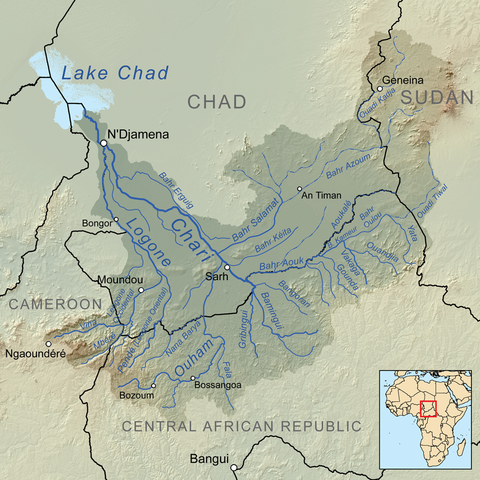
Chari River: Region including Lake Chad, Cameroon, and environs.
For more than 2,000 years, the Chadian Basin has been inhabited by agricultural and sedentary people. The region became a crossroads of civilizations. The earliest of these were the legendary Sao, known today only from artifacts and oral histories. They left no written records and are known only through archaeological finds and the oral history of their successors in the territory. Unfortunately, little is known about the Sao’s culture or political organization. One theory of the origin of the Sao states that they descended from the Hyksos, who conquered Ancient Egypt and later moved south, from the Nile valley to mid-Africa, after fleeing invaders.
Sao artifacts show that they were skilled workers in bronze, copper, and iron. They made bronze sculptures and terra cotta statues of human and animal figures, funerary urns, and highly decorated pottery. The Sao were made up of several patrilineal clans who were united into a single polity with one language, race, and religion.

Sao Sculpture: A Sao sculpture from Chad.
The Sao’s demise may have come about due to conquest, Islamization, or a combination of the two. Traditional tales say that the Sao west of Lake Chad fell to “Yemenites” from the east. If true, the newcomers may have been Arab Bedouin or Sayfuwa raiders coming from the east, who moved into the region in the 14th century CE. Although some scholars estimate that the Sao civilization south of Lake Chad lasted until the 14th or 15th century CE, the majority opinion is that it ceased to exist as a separate culture sometime in the 16th century CE.
The Sao fell to the Kanem Empire, the first and longest-lasting of the empires that developed in Chad’s Sahelian strip by the end of the 1st millennium CE. The power of Kanem and its successors was based on control of the trans-Saharan trade routes that passed through the region.
Today, several ethnic groups of northern Cameroon and southern Chad, particularly the Sara, claim to be descendants of the Sao. The Sara are an ethnic group who reside in southern Chad and Central African Republic. They make up 27.7% of Chad’s total population (year 1993 Census). Other ethnic groups in the Lake Chad basin area, including the Buduma, Gamergu, Kanembu, Kotoko and Musgum, also claim to be descended from the Sao.
2.2 – Ancient Carthage
2.2.1 – Overview
Ancient Carthage was a North African civilization that lasted from c. 650 BCE to 146 BCE.
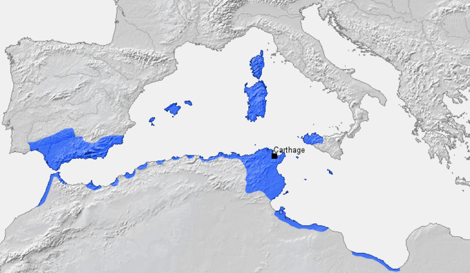
Carthage: Ancient Carthage in 264 BCE.
Ancient Carthage was a North African, Phoenician civilization that lasted from c. 650 BCE to 146 BCE. They were defeated by the Romans in 146 BCE. Carthage eventually extended across northern Africa and into the south of modern-day Spain.
2.2.2 – Culture
Carthaginian religion was based on Phoenician religion (derived from the faiths of the Levant), a form of polytheism. Many of the gods the Carthaginians worshiped were localized, and are now known only under their local names.
Carthage produced finely embroidered silks, dyed textiles of cotton, linen,and wool, artistic and functional pottery, and perfumes. Its artisans worked expertly with ivory, glassware, and wood, as well as with metals and precious stones. It traded in salted Atlantic fish and fish sauce (garum), and brokered the products of almost every Mediterranean people. In addition to manufacturing, Carthage practiced highly advanced and productive agriculture, using iron ploughs, irrigation, and crop rotation.
Carthaginian commerce extended by sea throughout the Mediterranean, and perhaps into the Atlantic as far as the Canary Islands, and by land across the Sahara desert. According to Aristotle, the Carthaginians and others had treaties of commerce to regulate their exports and imports.The empire of Carthage depended heavily on its trade with cities of the Iberian peninsula, from which it obtained vast quantities of silver, lead, copper and—
most importantly —tin ore, which was essential for the manufacture of bronze objects by the civilizations of antiquity.
Carthaginian trade-relations with the Iberians (and the naval strength that enforced Carthage’s monopoly on Iberian trade and that with tin-rich Britain), made it the sole significant broker of tin and maker of bronze in its day. Maintaining this monopoly was one of the major sources of power and prosperity for Carthage; Carthaginian merchants strove to keep the location of the tin mines secret. In addition to its role as the sole significant distributor of tin, Carthage’s central location in the Mediterranean and control of the waters between Sicily and Tunisia allowed it to control the eastern peoples’ supply of tin. Carthage was also the Mediterranean’s largest producer of silver mined in Iberia and on the North African coast; after the tin monopoly, silver was one of its most profitable trades.
Carthage also sent caravans into the interior of Africa and Persia. It traded its manufactured and agricultural goods to the coastal and interior peoples of Africa for salt, gold, timber, ivory, ebony, apes, peacocks, skins, and hides. Its merchants invented the practice of sale by auction and used it to trade with the African tribes. In other ports, they tried to establish permanent warehouses, or sell their goods in open-air markets.
Carthage obtained amber from Scandinavia, and from the Celtiberians, Gauls, and Celts they got amber, tin, silver, and furs. Sardinia and Corsica produced gold and silver for Carthage, and Phoenician settlements on islands, such as Malta and the Balearic Islands, produced commodities that would be sent back to Carthage for large-scale distribution. The city supplied poorer civilizations with simple products (such as pottery, metallic objects, and ornamentations), often displacing the local manufacturing, and meanwhile brought its best works to wealthier civilizations (such as the Greeks and Etruscans). Carthage traded in almost every commodity wanted by the ancient world, including spices from Arabia, Africa and India. It also participated in the slave trade.
2.2.3 – Military and Warfare
The military of Carthage was one of the largest military forces in the ancient world. Although Carthage’s navy was always its main military force, the army acquired a key role in the spread of Carthaginian power over the native peoples of northern Africa and southern Iberian Peninsula, from the 6th century BC to the 3rd century BC. Carthage’s military also allowed it to expand into Sardinia and the Balearic Islands. This expansion transformed the military from a body of citizen-soldiers into a multinational force composed primarily of foreign mercenary units.
Ancient Carthage was almost constantly at war with the Greeks or the Romans. One set of wars was called the Punic Wars. They were fought with Rome from 265 BCE to 146 BCE. The main cause of the Punic Wars was the conflict of interest between the existing Carthaginian Empire and the expanding Roman Republic. The Romans were initially interested in expansion via Sicily (at that time a cultural melting pot), part of which lay under Carthaginian control. At the start of the first Punic War, Carthage was the dominant power of the Western Mediterranean, with an extensive maritime empire. Rome, meanwhile, was the rapidly ascending power in Italy, which still lacked the naval power of Carthage.
It was during the Second Punic War that the Carthaginian leader Hannibal launched his famous overland attack on Rome. By the end of the third war, which began in 149 BCE, many hundreds of thousands of soldiers from both sides had been lost, and Rome succeeded in conquering Carthage’s empire. The Romans completely destroyed Carthage, and became the most powerful state in the Western Mediterranean. During this period, Rome emerged as the dominant Mediterranean power and one of the most powerful cities in classical antiquity. The Roman victories over Carthage in these wars gave Rome a preeminent status, a status it would retain until the 5th century CE.
3 – The Ancient Andes
3.1 – The Caral Civilization
The Caral civilization flourished in the Andean region between the 30th and 18th centuries BCE. This peaceful, urban center yielded several major discoveries, including a method of keeping records known as quipu.
3.1.1 – Overview
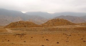
Caral: The remains of the Caral site in Peru
The Caral civilization (also known as the Norte Chico civilization and as Caral-Supe) was a complex pre-Columbian society, located in what is now the Norte Chico region of north-central coastal Peru, near Supe, Barranca province, Peru (200 km north of Lima). Its location allowed it to take advantage of three rivers: the Fortaleza, the Pativilca, and the Supe. It has been established as the oldest known civilization in the Americas, and as one of the six sites where civilization separately originated in the ancient world.
The Caral flourished between the 30th and 18th centuries BCE. This complex society arose a millennium after Sumer in Mesopotamia, was contemporaneous with the Egyptian pyramids, and predated the Mesoamerican Olmec by nearly two millennia.

Caral Temple: A view of the Caral temple
Caral was discovered by Paul Kosok in 1948, and further studied by archaeologist Ruth Shady. The urban complex of Caral takes up more than 150 acres, and holds plazas, dwellings, and a 28-meters-high temple. Its urban plan was used by Andean civilizations for the next four thousand years. One of the artifacts found at Caral is a knotted textile piece named a quipu, which archaeologists believe was a method of keeping records. Other pieces found include flutes made of condor and pelican bones, and cornetts made of deer and llama bones. Evidence of warfare has not been found. A geoglyph was discovered in 2000 by Marco Machacuay and Rocio Aramburu just west of Caral. The lines of the etching form a human face with long hair and an open mouth. At its peak, approximately 3,000 people are believed to have lived in Caral.
3.1.2 – The Norte-Chico Region
In archaeological nomenclature, Norte Chico civilizations are pre-ceramic cultures of the pre-Columbian Late Archaic; they completely lacked ceramics and apparently had almost no art. The most impressive achievement of these civilizations was its monumental architecture, including large earthwork platform mounds and sunken circular plazas. Archaeological evidence suggests use of textile technology and, possibly, the worship of common god symbols, both of which recur in pre-Columbian Andean cultures. Sophisticated government is assumed to have been required to manage the ancient Norte Chico. Questions remain over its organization, particularly the political influence of food resources. Some scholars have suggested that Norte Chico was founded on seafood and maritime resources, as opposed to the development of agricultural cereal and crop surpluses, which have been considered essential to the rise of other ancient civilizations.
3.2 – The Chavín Civilization
The Chavín civilization, which lasted from 900-250 BCE in Peru, featured ingenious art and architecture, and had widespread influence on other local cultures.
3.2.1 – Overview
The Chavín civilization developed in the northern Andean highlands of Peru between 900-250 BCE. Their influence extended to other civilizations along the coast. The Chavín civilization was located in the Mosna Valley, where the Mosna and Huachecsa rivers merge. It is now a UNESCO World Heritage site.
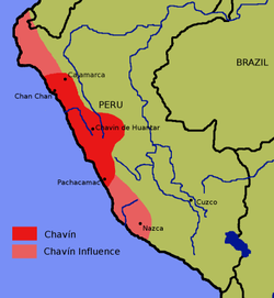
Map Showing Location of the Chavín: This map shows the location of the Chavín culture, as well as the areas the Chavín influenced.
3.2.2 – Stages of Development
Urabarriu lasted from 900-500 BCE, and just a few hundred people lived at Chavín de Huantar. Ceramics were influenced by other cultures, and the people grew some maize and potatoes. Chakinani, from 500-400 BCE, was a transitional time, when residents migrated to the ceremonial center. From 400-250 BCE, Jarabarriu saw a dramatic increase in population, with an urban/suburban pattern of settlement.
3.2.3 – Society
Chavín had a small, powerful elite that was legitimized through a claim to divine authority. These shamans were able to control and influence local citizens (probably partially through the use of psychotropic drugs), and were able to plan and carry out construction of temples and stone-walled galleries.
3.2.4 – Architecture
The chief example of Chavín architecture is the Chavín de Huántar temple. The temple’s design shows complex innovation to adapt to the highland environment of Peru. To avoid flooding and the destruction of the temple during the rainy season, the Chavín people created a successful drainage system with canals under the temple structure; the rushing water during the rainy season sounds like one of the Chavín’s sacred animals, the jaguar.
3.2.5 – Economic Activity
The Chavín people showed advanced knowledge of acoustics, metallurgy, soldering, and temperature control to accommodate the rainy season. The Chavín were also skilled in developing refined goldwork, and used early techniques of melting
metal and soldering.
The Chavín people domesticated camelids, such as llamas, which were used as pack animals, and for fiber and meat. The Chavin produced ch’arki, or llama jerky, which was commonly traded by camelid herders and was the main economic resource for the Chavín people. They also successfully cultivated several crops, including potatoes, quinoa, and maize. They developed an irrigation system to assist the growth of these crops.’
3.2.6 – Art
Chavín art represents the first widespread, recognizable artistic style in the Andes, and can be divided into two phases: the first phase corresponds to the construction of the “Old Temple” at Chavín de Huántar (c. 900-500 BCE); the second phase corresponds to the construction of Chavín de Huántar’s “New Temple” (c. 500-200 BCE). The Old Temple featured the Lanzón, which was housed in a central cruciform chamber in a labyrinth of underground passages. The Lanzón functions as axis mundi, or a pivot point linking the heavens, earth, and underworld.

The Lanzón at Chavín: Shown here is the most important stela statue of the central deity of the Chavín, called the Lanzón.
Chavín art decorated the walls of the temple and includes carvings, sculptures and pottery. Artists depicted exotic creatures found in other regions, such as jaguars and eagles, rather than local plants and animals. The feline figure is one of the most important motifs seen in Chavín art. It has an important religious meaning and is repeated on many carvings and sculptures. Eagles are also commonly seen throughout Chavín art. It was intentionally difficult to interpret and understand, as it was meant to be read by the high priests alone.

Incised Strombus-Shell Trumpet: This shell trumpet was likely used in ceremonies. The incised designs show a person of high rank playing a shell trumpet, surrounded by snakes.
The Tello Obelisk is a huge sculpted shaft decorated with images of plants, animals, including caymans and birds, and humans, which may be portraying a creation myth. Tenon heads are massive stone carvings of fanged jaguar heads, found at the tops of interior walls in Chavín de Huantar.
3.2.7 – Influence
Chavín had wide-ranging influence, with its art and architecture styles spreading for miles around. There is little evidence of warfare in Chavín relics; instead, local citizens were likely controlled by a combination of religious pressure and environmental conditions.
3.3 – The Valdivia Culture
3.3.1 – Overview
The Valdivia culture of Ecuador (3500-1800 BCE) is one of the oldest settled cultures recorded in the Americas. They were a sedentary, egalitarian people, known for their early use of pottery, and feminine ceramic figures.
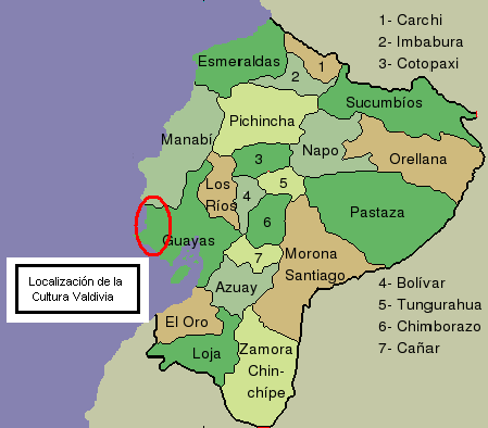
Map of Valdivian Culture: Shown here is the location of the Valdivia culture.
The Valdivia culture is one of the oldest settled cultures recorded in the Americas. It emerged from the earlier Las Vegas culture, and thrived on the Santa Elena peninsula near the modern-day town of Valdivia, Ecuador, between 3500-1800 BCE.
3.3.2 – Live among the Valdivians
The Valdivia lived in a community that built its houses in a circle or oval around a central plaza. They were sedentary, egalitarian people who lived off farming and fishing, and occasional deer hunting. From the remains that have been found, it has been determined that Valdivians cultivated maize, kidney beans, squash, cassava, chili peppers, and cotton plants, the latter of which was used to make clothing.
3.3.3 – Pottery
Valdivian pottery, which has been dated to 2700 BCE, was initially rough and practical, but over time became splendid, delicate, and large. Bowls, jars, and female statues were used in daily life and religious ceremonies. They generally used the colors red and gray, and polished dark red pottery is characteristic of the Valdivia period. In their ceramics and stone works, the Valdivia culture showed a progression from the most simple, to much more complicated works. Valdivians were the first Americans to use pottery.

Valdivian Pottery: Valdivian pottery is the oldest in America, on display in this image at the Museo de La Plata in Argentina.
The trademark Valdivia pottery piece is the “Venus” of Valdivia: feminine ceramic figures. The “Venus” of Valdivia likely represented actual people; each figurine is individualand unique, as can be seen in the hairstyles. They were made by joining two rollsof clay, leaving the lower portion separated as legs and forming the body andhead from the top portion. The arms were usually very short, and in most caseswere bent towards the chest, holding the breasts or chin.
3.3.4 – Trade
Valdivians created rafts with sails, and built a maritime trade network with tribes in the Andes and Amazon. A main trading item was the red shell of the thorny oyster, called Spondylus, which were often made into ornaments, and were considered more valuable than gold or silver.
Originally published by Lumen Learning – Boundless World History under a Creative Commons Attribution-ShareAlike 3.0 Unported license.