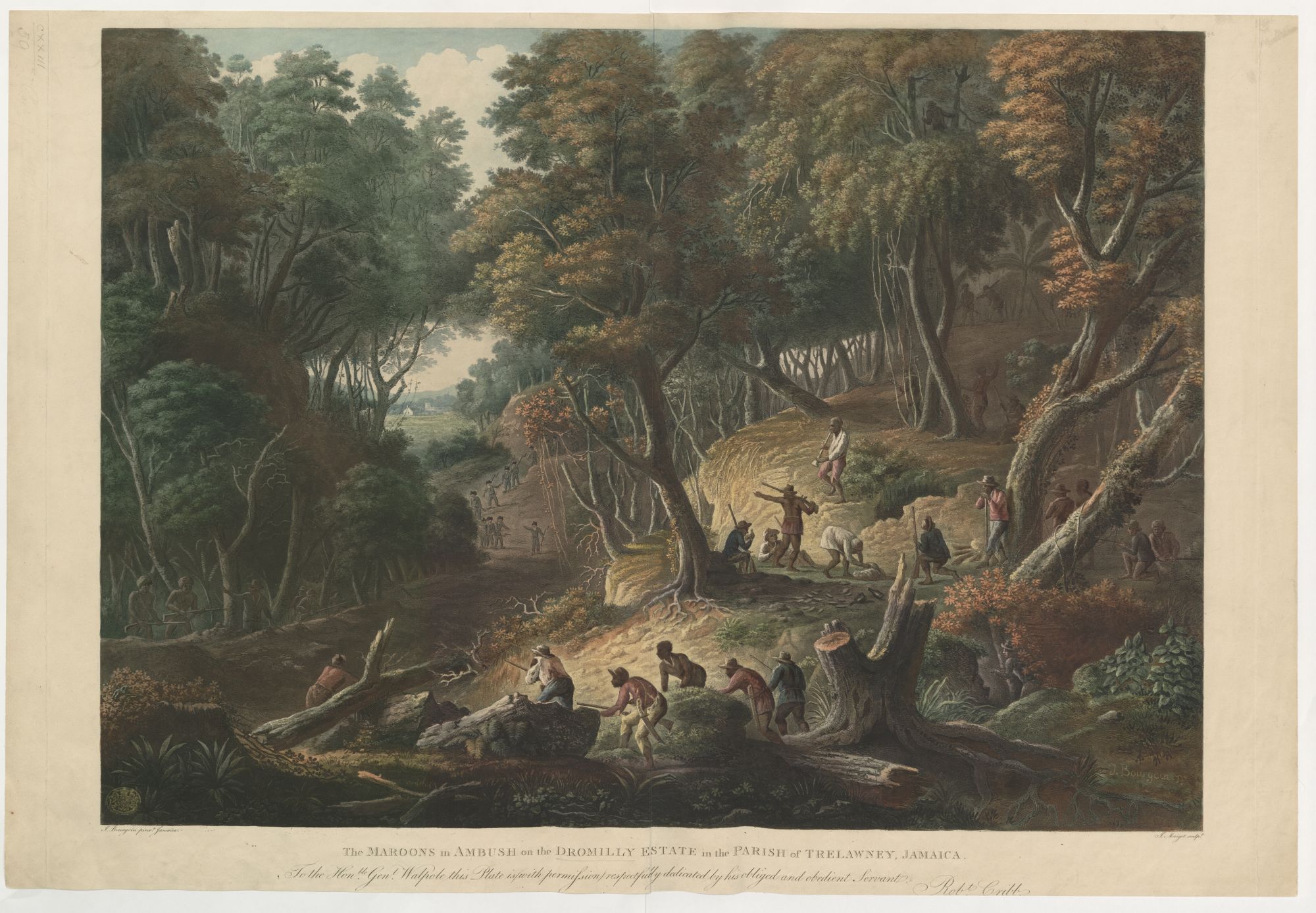
Maroons ambush British troops on the Dromilly Estate, Jamaica / British Library, Public Domain
Jamaican Maroons fought two major wars against the British during the 18th century. With reference to maps and views in the King’s Topographical Collection, Miles Ogborn investigates these communities of escaped slaves and their attempts to retain their freedom in a landscape of slavery.

By Dr. Miles Ogburn
Professor of Geography
Queen Mary University of London
What are we to make of this picture? Who were the Maroons? Where is this landscape? Why are the Maroons setting an ambush, and what does it mean that as viewers we see this scene as if from deeper in the woods, more from the viewpoint of the Maroons themselves than that of the soldiers coming up the path? Answering these questions and analysing this image requires an examination of how Jamaica, the Jamaican landscape and the Maroons were represented in the 18th and early 19th centuries when that island was at the centre of Britain’s imperial economy in the Americas.
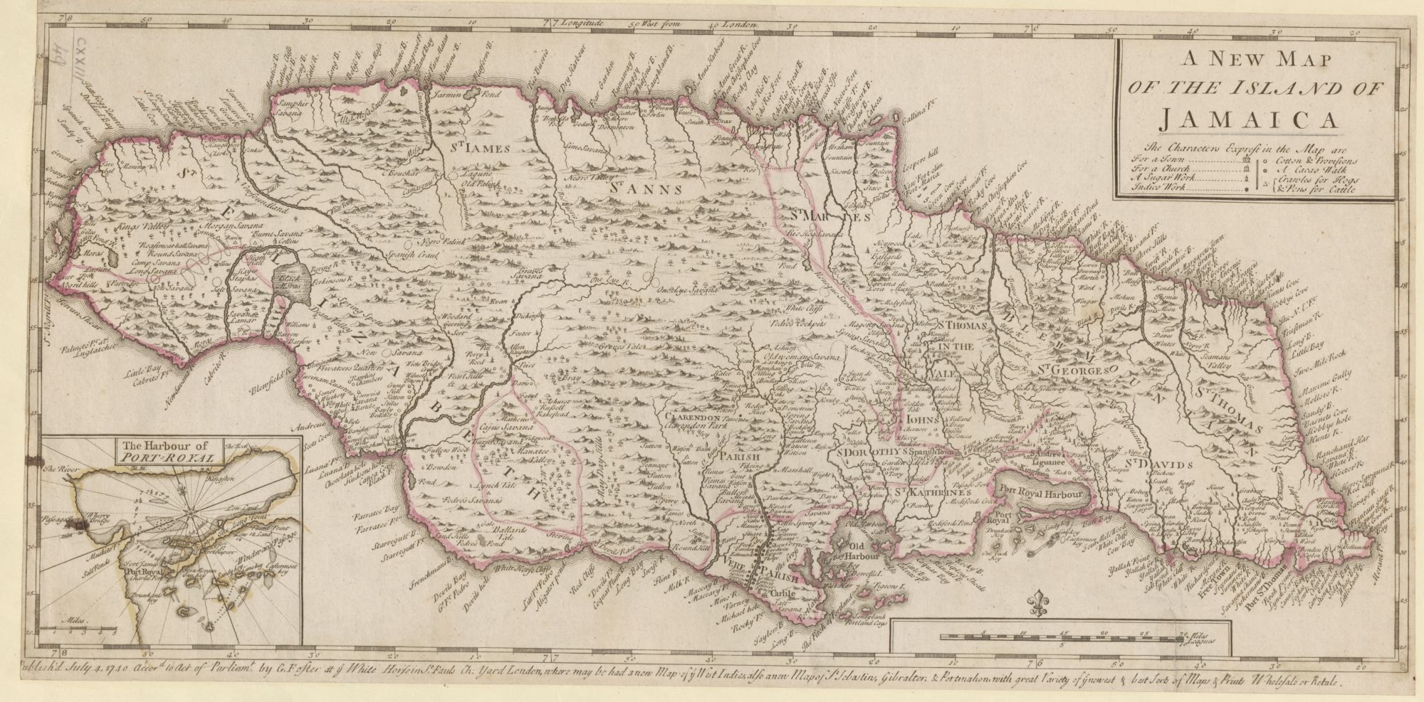
George Foster’s map of Jamaica published in 1740 / British Library, Public Domain
George Foster’s A New Map of the Island of Jamaica (1740) shows it as a British possession, as indeed it had been since 1655 when Oliver Cromwell’s forces had taken the colony from the Spanish. The island’s topography is studded, and its coast surrounded with English place names which make it a knowable and inhabited place. The parishes: St Elizabeth, St Ann’s, Clarendon, St Thomas in the Vale. The ports, towns, rivers and plantations: Port Royal, Kingston, Long Bay and Milk River; Sutton, Marshall and Watson. Indeed, Foster has taken care to represent the transformation that had happened in Jamaica under English rule: showing the location of indigo works, cacao walks (for chocolate), areas growing cotton and provisions, and those raising pigs and cattle. And most important of all, the plantations growing and processing sugar cane. The development of an economy based on sugar on the island had transformed its fortunes and its landscape. From the 1670s Jamaica had overtaken Barbados as the main sugar-producing island, and by 1739 it was producing 16,000 tons of sugar for export each year. This put the island right at the heart of Britain’s Atlantic empire.
There are, however, things that Foster’s map obscures too. Careful examination shows that the economic transformation was limited, at this stage, mainly to the coasts and the river valleys, and it was really only in the south that they covered any substantial part of the landscape. This was the lowest, most easily worked land, and Foster’s map obscures Jamaica’s dramatic terrain by naming only the ‘Blew Mountains’ in the east, and using mapping conventions to show relief, which fail to depict the extent of the high and thickly-wooded land that runs east-west across the island. The map also fails to indicate that the British hold on the island was partial. The many remaining Spanish place names (Ocho Rios, Cabrito Point, even the capital at Spanish Town) hint at its previous rulers, still eyeing the island from nearby Cuba, while the French did the same from their colony of St Domingue (now Haiti) just to the east. There were also internal threats. The sugar economy was built upon slavery. By 1740 Jamaica had a population of over 100,000 enslaved Africans and less than 10,000 white settlers.1 These enslaved workers resisted slavery in many ways, from avoiding work to outright violent rebellion, and the planters depended on violent corporal and capital punishments and the presence of the British army and local militias to keep control. There were, however, also those former slaves who had successfully freed themselves. Hundreds had escaped the Spanish plantations when the English had invaded the island in 1655, and had continued to fight the colonists and to raid their settlements. They were joined by others who slipped the bonds of slavery to live free beyond the control of the plantations and their owners.
These were the Maroons. By 1740 they had fought the British to a standstill in the mountains and signed a peace treaty (in 1739) which gave them sovereignty over their own lands in return for agreeing to provide military support for the colony and to catch and return plantation runaways. A British image of the peace treaty demonstrates the ambiguities in how these free black people were seen.
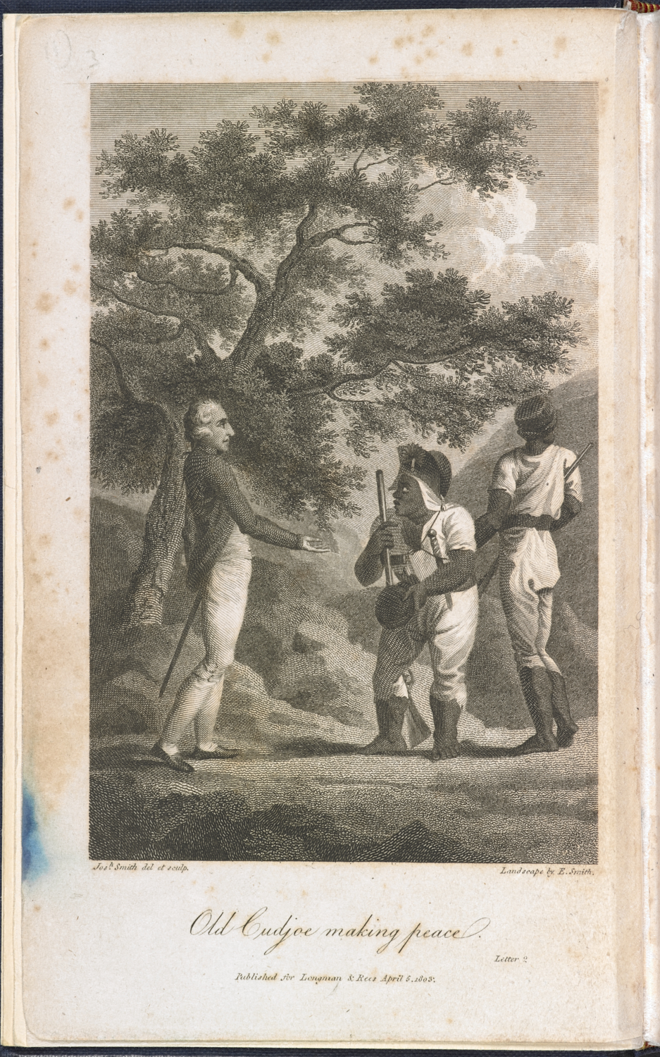
Old Cudjoe making peace: Colonel John Guthrie, a Jamaican plantation owner, meets Cudjoe, the leader of the Jamaican Maroons / British Library, Public Domain
It emphasises the differences between white and black in its depiction of the key treaty-makers – Captain Cudjo (or Kojo) and Colonel Guthrie – who had actually met as equals. But it also suggests – through the other, anonymous figure – the embodied skills of the Maroons which enabled them, unlike the British soldiers, to move quickly and easily through difficult country, attacking at key points and disappearing as fast as they came. After the treaty the Maroons lived in villages in the highlands and forests of the northern Blue Mountains in the east (the Windward Maroons) and in the Cockpit Country – so-named for its distinctive deep and rounded limestone hollows – where St James and St Elizabeth parishes met in the west (the Leeward Maroons). Yet there are only a few small signs of this country within a country on Foster’s map. At the head of the unnamed tributary that runs into the Camarones River in St James – perhaps from the Spanish cimarrón, or runaway – there is a place he has named ‘Negro Palink’: Palink being an anglicisation of the Spanish American word palenque, for a stockaded mountain settlement. This is in what would later become Trelawny parish, and Dromilly would be just a little further north.
The ways in which Foster’s map almost, but not quite, obscures both plantation slavery and resistance to it in his depiction of Jamaica is repeated again and again in other representations of the Jamaican colonial landscape. For an island whose most important landscape was the monoculture of the lowland sugar plantations with their waving sea of canes, worked by a coerced army of enslaved Africans who fed a semi-industrial production complex of cane mills and sugar boiling and curing houses, it is striking how little that is present in the visual record. Instead, there are images that present Jamaica in terms of a Georgic landscape of agricultural labour: a sublime landscape of mountains, rivers and forests or a picturesque landscape of ordered settlement.
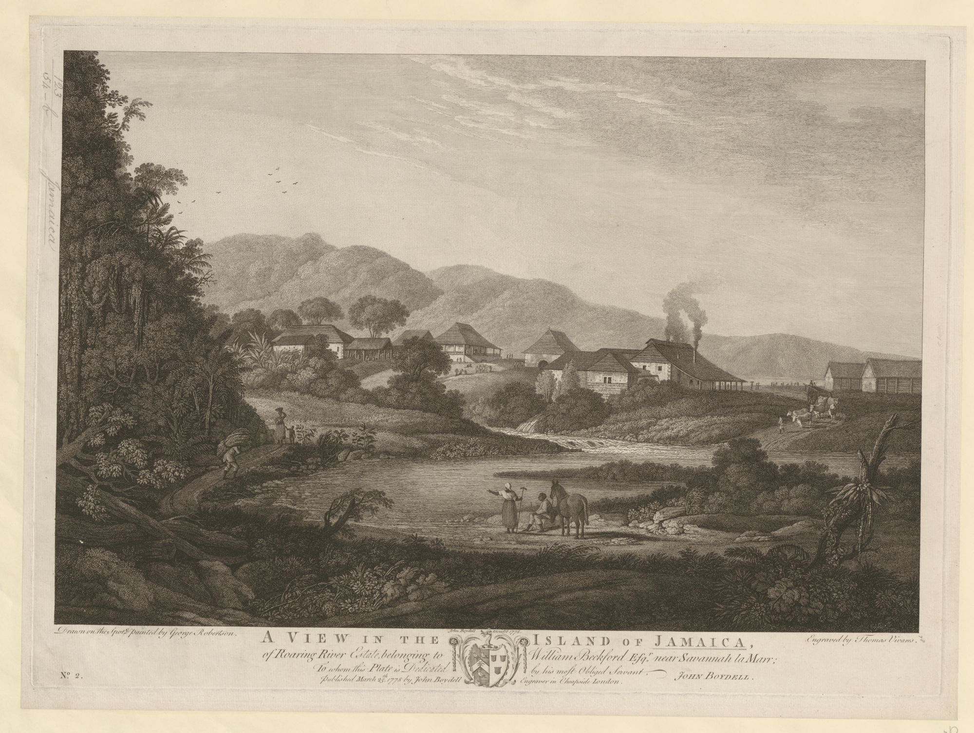

[LEFT]: A view of William Beckford’s Jamaican estate, Roaring River / British Library, Public Domain
[RIGHT]: A picturesque waterfall on Jamaica’s White River / British Library, Public Domain

Louis Bélanger’s view of the River Cobre near Spanish Town, Jamaica / British Library, Public Domain
In each case the different, disruptive and dangerous landscape of Jamaica – a place of death, disease and disorder for all who found themselves there – is brought to order through the conventions of European landscape depiction.[2] Yet at the same time the presence of enslaved figures in the landscape, exotic vegetation and dramatic craggy scenery disrupts this familiarity and hints that all is not the same in the Caribbean.[3] These elements of landscape depiction are also there in The Maroons in Ambush, but the resistant figures of the Maroons take centre stage, the picturesque lowland landscape recedes into the distance, and the sublime mountain forest envelops the viewer and the action. So, what is going on?
By the late 18th century the economic geography of sugar and slavery in Jamaica had moved on from that shown on George Foster’s map. There were now nearly 300,000 enslaved people on the island, and the frontier of the plantation complex in northwest Jamaica was beginning to push up the river valleys towards the lands of the Maroons. This inevitably provoked confrontation and conflict, which – prodded on by Governor Balcarres’ willingness not to waste a good crisis – escalated into full-scale warfare in 1795. Once again, the skillful guerrilla tactics of the Maroons in the forests and mountains proved a match for the large numbers of soldiers and militiamen deployed against them. Unable to win by conventional means, the British began destroying the Maroons’ provision grounds and brought in trained attack dogs from Cuba (which raised questions among both the army officers on the ground and among MPs in the House of Commons about colonial warfare and ethics). This was enough, after six months of war, to bring the Maroon leaders to sign a peace treaty with the leader of the British forces, General George Walpole, who gave his word that they would not be sent off the island if they complied with its terms.
Unfortunately for the Maroons, Jamaica’s political leaders had other ideas. They argued that the Trelawny Maroons had not complied with the precise terms of the treaty, in that they had not all surrendered in the very short time stipulated, and that they should therefore be exiled. The case was put to a wider public on both sides of the Atlantic by the historian and Jamaican assembly member Bryan Edwards in a book entitled The Proceedings of the Governor and Assembly of Jamaica, in regard to the Maroon Negroes (1796). Its frontispiece – an engraving of the young Trelawny Maroon leader Leonard Parkinson – struck a balance between the image of an individual fighting man and representing all Maroons, and between presenting them as a worthy and dangerous enemy and as what Edwards called ‘wild and lawless savages’.[4] Indeed, the precision of that balance is well demonstrated by a later version of the image which tilts much further towards presenting the Maroon as a stereotypical wild savage warrior. Such depictions helped cement the case for shipping the Trelawny Maroons to Nova Scotia, a long way from the mountains of Jamaica.

A portrait of the Maroon soldier Leonard Parkinson / British Library, Public Domain
However, General George Walpole did not fall into line. He became a thorn in the side of the colonial administration both in Jamaica and in London (where he became an MP), arguing wherever he could that he had not wanted the promise that he had given to the Maroons to be broken. His more sympathetic presentation of their case was one element – alongside their own wish to leave Canada, and the imperial government’s desire to have them fight for, rather than against, British interests – in transporting them to the abolitionist inspired, but politically turbulent, settlement of Sierra Leone in West Africa in August 1800. This, then, is the context for The Maroons in Ambush on the Dromilly Estate (1801). It is dedicated to General Walpole, and both draws on and transforms the conventions of Jamaican landscape depiction to present the world of plantation slavery and freedom from within the forested mountains of northern Jamaica. The picturesque colonial landscape is off in the distance, separated from the Maroons’ country of sublime tropical woodland, crags and dark mountain paths. The Maroons themselves are shown as a formidable, if somewhat undisciplined, force born from the ways in which African and European elements had combined in the Caribbean. While showing free black people it is not simply an image of black freedom, or of the world from the Maroons’ point of view. Yet it is an image that articulates some surprising elements: depicting the Maroons located in the place from which they had been exiled, and showing their military strength without resorting to caricature. That it does so through a representation of landscape helps us see more clearly the particular forms of power and vision that underpinned most images of colonial Jamaica.
Notes
- Richard B. Sheridan, ‘The formation of Caribbean plantation society, 1689-1748,’ in P.J. Marshall (Ed.) The Oxford History of the British Empire. Volume II: The Eighteenth Century (Oxford: Oxford University Press, 1998), pp. 394–414.
- Vincent Brown, The Reaper’s Garden: Death and Power in the World of Atlantic Slavery (Cambridge, MA: Harvard University Press, 2008).
- Kay Dian Kriz, Slavery, Sugar, and the Culture of Refinement (New Haven, Yale University Press, 2008) and Geoff Quilley, ‘Pastoral plantations: the slave trade and the representation of British colonial landscape in the late eighteenth century,’ in Geoff Quilley and Kay Dian Kriz (Eds) An Economy of Colour: Visual Culture and the Atlantic World, 1660–1830 (Manchester: Manchester University Press, 2003), pp. 106–128.
- Quoted in Miles Ogborn, ‘A war of words: speech, script and print in the Maroon War of 1795–6,’ Journal of Historical Geography 37 (2011) pp. 203–215.
Originally published by the British Library under a Creative Commons Attribution 4.0 International license.