Possible ideological and social changes that led to a new chronological-cultural stage: the Early Bronze Age.

By Dr. Ana M.S. Bettencourt
Assistant Professor of History
University of Minho
Abstract
The Northwest Iberian Peninsula is not a uniform region. Geographers have divided it into two main biogeographic sub-regions: Atlantic and Mediterranean, each with its own characteristics, in terms of geomorphology and climate. The perception that these two sub-regions have distinct identities since, at least, the first half of the 3rd millennium BCE, i.e. since the Chalcolithic period, has led us to analyse separately developments in the last quarter of the 3rd millennium BCE, which is viewed as a key period for understanding the emergence of the Bronze Age.
During the Early Bronze Age new settlement strategies emerged in the Atlantic sub-region, associated with the appearance of innovative pottery shapes and decorations, resettlement of high-altitude areas for burial in small cairns, circulation of new prestigious metallic icons, the emergence of new styles of rock art, such as engravings of dozens of halberds, the emergence of the phenomenon of structured depositions of metallic objects, such as the deposits of halberds, or halberds and daggers, and, consequently, new social relationships, new power structures and new places for negotiating social relations, which revealed significant structural changes compared to Chalcolithic communities.
In the Mediterranean sub-region, despite new locations for certain settlements, changes seem to have occurred across a broader timeframe, including the abandonment of several community and ceremonial spaces – such as walled enclosures or shelters with collective depositions –, the emergence of metallic deposits, consisting of halberds, and the timid adoption of new iconographies in rock art. These are characterised by phenomena of continuity or social resistance, and reveal that, in this region, social changes and new scenarios of power or social aggregation occurred in a manner that differed from the Atlantic sub-region.
On the basis of the analysed data it seems possible to hypothesise that, during the last quarter of the 3rdmillennium BCE, together with the phenomena of social resistance and permeability to new developments, the Northwest Iberian Peninsula was subjected to multiple and distinct influences that spawned the development of a mosaic of societies, apparently united and standardised by generalised phenomena.
The factors that contributed to this change were multiple and distinct in each of the two sub-regions. This includes important external factors, such as the climate conditions in the middle of the 3rd millennium BCE and events that occurred during the second half of this millennium, that had distinct repercussions on the two sub-regions; greater or lesser permeability to Atlantic contacts; ‘dismantling’ of supra-regional exchange networks with southern regions, as a result of social upheavals in the Southern Mediterranean. In terms of internal factors, it is worth highlighting the capacity for resilience and adaptation to changes. Phenomena such as the migration of populations of Pontic-Caspian origin during the second half of the 3rdmillennium BCE, revealed by DNA studies of human remains from the South, Southeast, and Southwest Iberian Peninsula, are not proven for this region, and therefore will not be taken into account.
Introduction
This article aims to identify the changes that occurred in the Northwest Iberian Peninsula in the second half of the 3rd millennium BCE in order to identify the moment of possible ideological and social changes that led to a new chronological-cultural stage: the Early Bronze Age (EBA), compared to the previous period, the Chalcolithic Age (CA). The study will be carried out taking into account changes in population, pottery assemblages, funerary habits and contexts, rock art, and changes in supra-regional exchange networks. The existing data for this stage are uneven in terms of the quantity and quality of information, and differ between the two sub-regions. There is also no systematic radiocarbon dating programme that makes it possible to specify much of the known data. The holistic discourse that is intended herein will therefore only enable interpretations using a broad scale of analysis, with the reductionism that this implies.
The Northwest Iberian Peninsula is not a uniform region. Geographers have always divided it into two major biogeographic sub-regions: Atlantic, with an Atlantic influence, and Mediterranean, with a continental influence, each with its own characteristics in terms of geomorphology and climate. The perception that there are distinct identities in these two sub-regions since, at least, the first half of the 3rd millennium BCE (Lopes and Bettencourt 2017), corresponding to the period termed the Chalcolithic period, led us to analyse the proposed theme separately for each sub-region.
The Northwest Iberian Peninsula
The Northwest Iberian Peninsula can be divided into two geographic sub-regions: a) the Atlantic sub-region, open to Atlantic influences, to the west and north, with a coastline that is marked by numerous fjord-like estuaries (rias) (that still exist in the northernmost zone and in the southernmost zone, in the Portuguese territory)1 and b) the Mediterranean sub-region, more inland and with a Mediterranean climate, separated from the Atlantic sub-region by the eastern mountains of Galicia (NW Spain), and the mountain ranges of 1 It should be noted that Martínez-Cortizas et al. (2009), inter alia, consider that during the period of this study, due to conditions of neo-glaciation and greater dryness, the coast would have had more inlets and lagoons, thereby enabling the exploitation of salt. Padrela, Alvão, Marão, Montemuro, and Caramulo in North Portugal.
The geographic relief of the Atlantic sub-region resembles a natural amphitheatre, stretching from the coast to the interior (Ferreira 2005), interrupted by valleys running in South–North, East–West, and Northeast–Southwest directions, that constitute true circulation corridors – such as the Mandeo, Anllóns, Xallas, Tambre, Ulla, Lérez, Minho, Lima, Cávado, Ave, and Douro rivers, and the Sousa, Tâmega and Paiva sub-basins, tributaries of the Douro.
The Mediterranean sub-region is characterised by very flat plateaus that are part of the Meseta Central, intersected by more or less deep valleys and important tectonic depressions, such as those in Vilariça and Longroiva, which correspond, in part, to the western end of the plateaus of Castilla la Vieja, in Spain.

The Atlantic sub-region (Asturias, westernmost area of Galicia and North Portugal) is generally humid, with several climatic nuances due to the greater or lesser exposure to humid oceanic winds and high altitudes (Lautensach 1967). The Mediterranean sub-region (Southeast Galicia, Trás-os-Montes and Beira Transmontana) has dry summers and a Mediterranean climate, with continental influence, although Southeast Galicia remains more humid, notwithstanding the higher altitude (Lautensach 1967) (Figure 1).
The Cultural Background
Overview
To understand the changes that occurred in the transition from the 3rd to the 2nd millennia BCE, it is necessary to characterise the communities that preceded it, i.e. those that existed from the end of the 4th millennium BCE until the mid/third quarter of the 3rd millennium BCE, classified in this text as the Chalcolithic period.
Chalcolithic Identities
This period has been studied in greater depth in the Mediterranean and Atlantic sub-regions of Portugal and in some parts of the Atlantic sub-region of Galicia (Spain). Based on the data, two main identity-based zones have been identified2 that seem to articulate with the two aforementioned biogeographic regions: the Mediterranean and Atlantic, materialised by different decorative matrices inscribed on the pottery assemblages (Jorge, S. 1986; Lopes and Bettencourt 2017), and also by the symbols engraved in the different styles of rock art (Atlantic and Schematic), which are presumably associated to different forms of social organisation.
In the Atlantic sub-region, from the southern section of the province of A Coruña, through the southwest of Galicia (Fábregas Valcarce 2001) to the Douro Littoral, the dominant type of pottery is the Penha-type incised/impressed pottery, at least by the mid 3rd millennium BCE, with metope-like decorative organisations (Jorge, S. 1986; Lopes and Bettencourt 2017), as well as a greater profusion of Classical Atlantic rock art, that has persisted since the Neolithic era (Alves 2003). In the Mediterranean sub-region, from the easternmost section of the province of Ourense to the Alto Douro, including the northeast section of Trás-os-Montes, combed pottery with horizontal or wavy decorative organisations, and some Schematic rock art motifs3 prevails (Lopes and Bettencourt 2017). However, it is possible to note permeability between these different identity-based zones, especially along the Douro and its tributaries – true natural corridors for the circulation of people, ideals, materials, objects and techniques.
In each of the identity-based areas, evidence indicates a strong exchange with more southern areas, both along the coast and across the interior circulation corridors.
For example, Penha-style pottery and Atlantic-style rock art are found, at least, up to the Mondego basin, not as predominant elements, but as exceptions – for example, the Tapada do Espinheiro site and the presumed enclosure of Chãs, both in Cantanhede, Coimbra (Bettencourt 2005; Cruz 2005; Cruz et al.2011).4 This permeability is also revealed by interior circulation corridors, between the northeast of Trás-os-Montes, the Alto Douro and Beira Alta, through combed iconographies, where they also constitute exogenous elements (Valera 2007). This widespread permeability implies well-established, supra-regional exchange networks, in an area of the Iberian Peninsula that is assumed to be relatively peaceful, at least in the first half of the 3rdmillennium BCE.
Supra-regional Interactions
This period was also marked by a large number of foreign influences, from south to north, wherein the Northwest Iberian Peninsula became more ‘influenced’ by artefacts, materials, techniques, and ideologies of southern origin. This phenomenon was also linked to the major social and economic dynamism that occurred in the south of the Iberian Peninsula (Nocete 2001; Nocete et al. 2005; Cruz Berrocal et al. 2013; Gilman 2013; Soares 2016; García Sanjuán 2017; Valera 2019; among others).
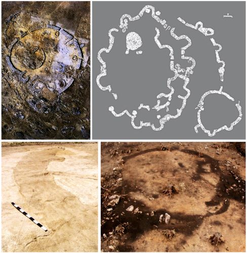
These influences led to the emergence of walled enclosures, which were more common in the eastern section of the Northwest Iberian Peninsula, for example, Castelo Velho de Freixo de Numão (Jorge S. 1994; 2014; Lopes 2019) and Castanheiro do Vento (Cardoso 2007; Vale 2011), both in Vila Nova de Foz Côa, Guarda; Crasto de Palheiros, in Murça, Vila Real (Sanches 2008), and other sites, as identified in the archaeological field-surveys undertaken by Cardoso (2007). Further north, the same phenomenon is also identified at El Pedroso, Trabazos, Zamora (Delibes de Castro et al. 1995), on the border with Portugal. In the most western façade of the Northwest Iberian Peninsula, there are also walled enclosures, such as those located at Chás, Oimbra, Ourense (Gómez Fernandez et al. 2004),5 Mesa de Montes, Cangas do Morrazo, Pontevedra (Fábregas Valcarce 2010: 111) and Sola I, Braga (Bettencourt 2000). Complex ditched enclosures are also found, for example at Forca, in Maia, Porto (Valera and Rebuge 2008; Bettencourt 2010b; 2013; Bettencourt and Luz 2013; Loureiro 2017) and Montenegro,6 in Moaña, Pontevedra (Gianotti and Cancela 2005), although the latter has been related with possibly funerary events, or with timber circles of Atlantic tradition (Gianotti et al. 2011) (Figure 2).
It was also within the framework of these supra-regional networks that the emergence of copper mining and metallurgy was introduced in the Northwest Iberian Peninsula. The respective data are documented by analyses of environmental archives that have detected evidence of regional atmospheric pollution and the contamination of soils by heavy metals, as a result of this activity, conducted at La Molina mire, Salas, Asturias, in Northern Spain, throughout the 3rd millennium BCE, although with greater impact in the second half of the 3rd millennium BCE (4030-3700 BP) (Martínez Cortizas et al. 2015). This highlights another former copper mining area in western Asturias, because the isotopic signature of ores from copper mines in Northern Spain,such as El Milagro, in Riosa, located 35 km south-east of La Molina, and El Aramo,in Cangas de Onís, 100 km east,is clearly different from that of La Molina(Martínez Cortizas et al. 2015: 403). El Aramo seems to have started its activity between 2500-2400 BCE, although there was a first occupation between 2679-2470 BCE (88.8%) (4045±40 BP) in the settlement of La Campa les Mines, located outside the mine (Blas Cortina et al. 2013).
Other evidence of copper metallurgy are the first copper crucibles and waste, and a possible fragment of tuyere in some Chalcolithic settlements, as well some flat axe stone moulds from the westernmost region (Jorge 1986; Comendador Rey 1998) and evidence of crucibles, fragments of tuyere slag and moulds linked to the production of several copper objects in settlements
and enclosures in the easternmost sub-regions (Sanches 1997; Delibes de Castro et al. 2005; Vieira 2015). Associated with this activity or exchanges is the manipulation of copper artefacts, namely flat axes, chisels, sticks, saws, Palmela points, and some small daggers that have been found in different contexts (settlements, enclosures, funerary monuments, in fissures of outcrops engraved with rock art) as highlighted by several authors (Jorge, S. 1986; Cruz 1992; Alves and Comendador Rey 2009; Lopes and Bettencourt 2017, among others).
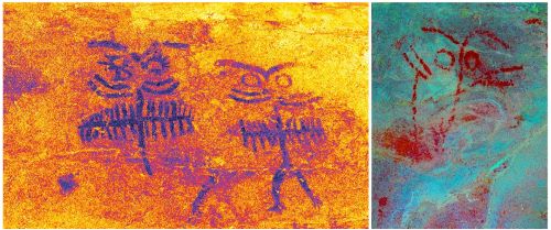
The expansion or adopted model of maritime and linear and geometric Bell Beaker pottery almost certainly began in this period, as well as the associated rites, given the antiquity of these containers in southern locations (Cardoso and Soares 1990-1992; Cardoso 2005a; Cardoso 2014-2015), based on some radiocarbon dates of findings in the North of Portugal (Barbosa 1999; Sanches 2000-2001; Jorge, S. 2002; Jorge, V. et al. 2002; Bettencourt and Luz 2013; Teixeira 2019), and in more northern areas of the Northwest Iberian Peninsula, that do not exceed the third quarter of the 3rd millennium BCE (Alonso Mathías and Bello Díeguez 1995; Fábrega Valcarce et al. 2007; Bradley et al. 2015).7 Another manifestation of southern influence is the appearance of new symbols, such as ocular motifs, which reflect the circulation of a supra-regional ideological background8 and that are found, especially, in the Mediterranean sub-region, either in ceramic containers, e.g. S. Lourenço, Chaves (Jorge, S. 1986); Castelo Velho de Freixo de Numão, Vila Nova de Foz Côa (Lopes 2019); shelter 1 of Buraco da Pala, in Mirandela (Sanches 1997); or in painted rock shelters, e.g. Serra de Passos 1/Regato das Bouças 15, Serra de Passos 3/Regato das Bouças 11 (Figueiredo 2013; Sanches et al. 2016), Regato das Bouças 1 and 2, all in Mirandela (Sanches et al. 2016), and Pala de Cabras, in Casaio, Carballeda de Valdeorras, east of Galicia, still under study (Figure 3). In the Atlantic sub-region, examples have been found in settlement and burial contexts, e.g. Chã do Castro, in Amares, Braga (Jorge 1986); Mount of Penha, in Guimarães (Pina 1928) and O Buriz mound (Rodríguez Casal 1990).
This permeability to innovation seems to extend to the countless stelae with features similar to those of the interior and southern zones of the Iberian Peninsula, mainly located in the Mediterranean sub-region of the Northwestern Iberian Peninsula, with rare extensions to the Atlantic sub-region. This seems to be the case with the important enclosure of stelae in Cabeço da Mina, in Vila Flor (Sousa 1996; 1997; Sanches 1997; 2011; Jorge, S. 1999b; Lopes and Bettencourt 2017), where weapons are absent and present ‘….great stylistic schematism, (in addition to) anatomical motifs (eyes, nose, mouth, arms, possibly legs and sex) and complementary motifs (belts, necklaces, insignia, etc.’ (Lopes and Bettencourt 2017: 14). The chronological assignment of this enclosure to the Chalcolithic period is also based on the fact that the face sides of some of these stelae seem to resemble ocular motifs.
It is likely that in these networks of exchanges – in which people, ideas, techniques, objects and materials were traded – copper (more abundant in the south) and variscite played a significant role, especially since they would have been matters of great social importance and attributed major symbolism and properties.9 Variscite existed in the north of Aboboreira and in eastern Trás-os-Montes (Ferreira et al. 1999), as well as in the northern Meseta (Mediterranean sub-region) and in the south of Galicia (Fábregas Valcarce and Rodríguez-Rellán 2019).
However, given the permanence of identities, alterations of exogenous origin must be related to societies that adopted and adapted new styles within the framework of a traditional cosmological universe, with greater or lesser autonomy, depending on the different regions.
Settlements and Subsistence Strategies
During this period, throughout the Northwest Iberian Peninsula there was an increase in the number of settlements. In the Atlantic sub-region, settlements occurred in areas of medium or low altitude, usually offering panoramic views over the surrounding irrigated valleys or coastal platforms, in places often with profusions of rock shelters or granite outcrops (Jorge 1986; Fábregas Valcarce 2001; Bettencourt 2005b; Fábregas Valcarce et al. 2007; Bettencourt 2009a; 2013; Lopes and Bettencourt 2017). Some are located in granitic alveoli, in low-lying plateaus or in low elevated hills of the coastal platform (Bettencourt 2005a; 2009a; 2013). In the Mediterranean sub-region, Sanches (1997) has divided settlements into two types: those that would have a territory with a high productive capacity in relation to agro-pastoral activities, using rudimentary technologies, and those located in ‘poorer’ and more rugged territories that she considered may have been complementary to the former, with more seasonal occupation.
In both sub-regions, the quantity of ceramic and lithic materials found, the existence of some stone walls (sometimes demarcating artificial platforms), or the stratigraphy reveal long periods of human occupation, thereby indicating greater sedentarisation than in the previous period.
In both sub-regions, easy access to a diversity of areas with different edaphic and topo-climatic conditions near the settlements would have facilitated rational land management of the territory for the cultivation of different types of cereals or legumes and the grazing of different types of domestic animal species. In this manner, in terms of pastoral agro-silvo activities, the communities in both sub-regions appear to have had well-developed sources of subsistence, complemented by hunting and gathering activities of vegetables and fruit, and seafood, in coastal areas (Sanches 1997; Figueiral and Sanches 1998-1999; Fábregas Valcarce 2001; Bettencourt 2009; 2013; Bettencourt et al. 2017b).
As a result of this increase in human activity, there was a certain regression of forestry areas around these settlements and an increase in erosion processes, also influenced by the climatic deterioration that occurred in this period (Martínez Cortizas et al. 2000), at least in the Atlantic sub-region.
In the Mediterranean sub-region, the local populations cultivated cereals, such as dress and bare wheat (Triticum dicoccum and Triticum aestivum), barley (Hordeum vulgare), legumes, such as peas (Pisum sativum) and broad beans (Viciafaba) and also flax and linseed, associated with the collection of, at least, acorns, pine nuts, tree-strawberry berries (Arbutus unedo). The opium poppy (Papaver somniferum) was also consumed (Ramil Rego and Aira Rodrigues 1993; Sanches 1997; Figueiral and Sanches 1998-1999; Sanches et al. 2007; Bradley et al. 2015). Shepherding is documented by the appearance of domestic species, such as cattle (Bos taurus or Bos sp.) and sheep/goats (Ovis aries/Caprahircus), although pig/wild boar (Sus sp.) are also found in almost all archaeological sites of this period. Wild animals, such as horse, deer, wild boar and rabbit were scarce (Sanches 1997; Cardoso and Costa 2004; Cardoso 2005b; Costa 2007; 2008).
In the Atlantic sub-region, remains of cereals have been documented, such as bare wheat (Triticum aestivum/compactum) and dress barley (Hordeum vulgare), and legumes, such as broad beans (Viciafaba). Flax (Linum sp) has also been found, but we are unable to ascertain whether it corresponds to cultivated or wild species. There were gathering activities of roasted acorns, blackberries, and wild radishes (Raphanus raphanistrum) (Ontañón Peredo 2003;Bettencourt et al. 2007b; Figueiral and Bettencourt 2007). It is worth mentioning the appearance of silene, a plant suited to dry to slightly humid soils, during the first half of the 3rd millennium BCE, in the settlement of Bitarados, very near the coast (Figueiral and Bettencourt 2007). Remains of ovicaprines and perhaps ox indicate the breeding of cattle. Deer remains point to the consumption of wild animals (Ontañón Peredo 2003;Cardoso and Bettencourt 2008). Swine are also present (Jorge 1986). These populations also collected or hunted deer, rabbits, bustards (cf. Otis tarda) and horses (Equus caballus) (Jorge 1986; Fernández Rodríguez 2000; Fernández Rodríguez and Ortiz 2007).
The World of the Dead
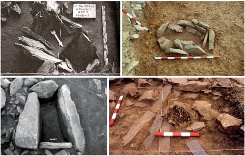
With regard to the first half of the 3rd millennium BCE, both in Portuguese and Spanish territories (Galicia and Asturias), and in the Atlantic and Mediterranean sub-regions, there is great invisibility of funerary contexts, with a diversity of solutions in rites and contexts and the emergence of individual graves. The latter phenomenon can be observed in the necropolis of cists used for inhumation burials, covered with small stone mounds (cairns) at Vale da Cerva, Vila Nova de Foz Côa, Guarda, in a riverside area, in the vicinity of Schematic rock art (Baptista 1983; Cruz 1998), in one cist with cremation remains in Agro de Nogueira, Melide, Lugo, also in a riverside area (Bettencourt and Meijide Cameselle 2009), and in the small burial cist in A Devesa de Abaixo, Moaña, in Pontevedra, dated 2707-2570 BCE10 (Vázquez Liz and Prieto Martínez 2016) (Figure 4).
In the Mediterranean sub-region there is documented evidence of the use of cavities for burials. Such is the case of the inhumation burial sites at Lorga de Dine, in Vinhais, Bragança (Pereira et al. 2018) and probably in Gruta de Ferreiros and Gruta Grande, in Miranda do Douro (Sanches 1992), for the materials associated to the corpses. In the same sub-region, manipulation of secondary human remains occurred in the monumental walled enclosure of Castelo Velho de Freixo de Numão (Jorge et al. 1998-1999) (Figure 4).
No megalithic monuments from this period are known in either region, perhaps with two exceptions, in the Atlantic sub-region, of an atypical earth mound in Aspra, at Caminha, Viana do Castelo, with a pit chamber and only Bell Beaker pottery as deposits (Lopes and Bettencourt 2017), and another, Lousada 5, at Xermade, Lugo where one or more corpses were deposited with incised-metope-type vessels and concave-base arrowheads (Fábregas Valcarce and Vilaseco Vázquez 2004).
Several tombs with mounds constructed mainly with stone blocks (cairns) were built in the Atlantic sub-region, but only from the third quarter of the 3rd millennium BCE, apparently after an interregnum in construction. Examples include Regedoura, at Fafe (Pereira 2018), Illade 3 and Reboredo I, both at A Coruña (Vaquero Lastres 1995).
However evidence does exist of the reuse of megalithic monuments, either through architectural remodelling, such as Dombate, in Cabana de Bergantiños, in the province of A Coruña, which occurred in the first half of the 3rd millennium BCE, or its use between c. 2589-2469 BCE, through the deposition of Bell Beaker containers (Alonso Mathías and Bello Díeguez 1995). There is also evidence of depositions of Chalcolithic vessels with incised motifs, one with ocular motifs at Monte Pirleo 5, at Buriz, Guitiriz, Lugo (Fábregas Valcarce and Fuente 1988), of containers of Penha-type tradition at Cotogrande 5, Vigo, Galicia11 (Abad Gallego 1992-1993), and at Mamoa da Fábrica, Viana do Castelo (Silva 2003), among other poorly contextualised data (Gómez Fernandez et al. 2004). It is likely that many instances of reuse of monuments, materialised through depositions of Bell Beaker vessels (Jorge, S. 2002; Bettencourt 2011), must have occurred, at least, from the third quarter of the 3rd millennium BCE.
In Asturias, the mine galleries of El Aramo were also used for funerary purposes, from the middle of the 3rd millennium BCE (Blas Cortina 2003).
In short, in this period there was a change in the social role of death, the corpse and funerary architecture, with the loss, at least systematically, of the importance of the cult of ancestors, and the end of construction of monumental buildings dedicated to the dead, alongside the development of individual burials, where bodies buried in large-scale dolmens or in the ancestors’ territory would have been agents in the processes of appropriation and incorporation of the past in the new world view.
The new landmarks were monumental walled or ditched enclosures, within which there is recurrent evidence of structured depositions of different categories of artefacts, as at Castelo Velho (Lopes 2019), Castanheiro do Vento (Vale 2011), Castro Palheiros (Sanches 2008), and Fraga da Pena (Valera 2007), materialising a cosmogonic universe that is distinct from the Neolithic period, as has been defended for the Atlantic sub-region (Bettencourt 2009; 2013).
The Final Quarter of the 3rd Millennium BCE: The Data
Overview
The final quarter of the 3rd millennium BCE and the beginning of the 2nd millennium BCE is a difficult period to study, either because archaeological sites are difficult to find, or because many of the excavations carried out at some are sporadic and rarely published. Over recent years, and, in most cases resulting from preventive archaeology, there has been a higher number of findings from this period, accompanied by some more or less monographic studies, which make it possible to review this situation. However, the very uneven published contributions makes it difficult to analyse this phenomenon in the Northwest Iberian Peninsula. One of the main problems is the lack of vertical stratigraphy at many excavated sites, and the premise defended by some Galician authors, such as Prieto Martínez (2011), that the existence of the Bell Beaker pottery immediately refers to this chronological stage. This impedes careful and concrete analysis of the chronological dating of many archaeological sites found on the surface, or without vertical stratigraphy. Archaeological knowledge is essentially achieved, and as a starting point, through well-contextualised data, and only on the basis of that knowledge has it been possible to analyse other contexts. This text has been written using this methodology, and although it focuses on the aforementioned period, it sometimes compares the data with the immediately preceding or subsequent historical periods, to ensure a fuller understanding of the phenomena of change and continuity.
Taking into account the two biogeographic sub-regions of the Northwest Iberian Peninsula, each has been studied individually, prior to comparing them in section 5 of this text.
The Atlantic Sub-region (Settlements)
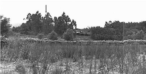
In the Atlantic sub-region, the population data are equally dispersed and reveal different land occupation strategies. In a valley setting, nearby well-irrigated fields with agricultural potential, the settlements of Setepías at Cambados, Monteverdi, near the Ría de Arosa estuary (Acuña 2003; Acuña Piñero et al. 2011), of Boucinha/Regueira, at Ponte de Lima, Viana do Castelo (Bettencourt et al. 2004; Bettencourt 2010a) (Figure 5) and of Rossio, at Vale de Cambra, Aveiro, are known, wherein the latter two have pits. In the coastal zone there is a settlement at Guidoiro-Areoso, at Vilanova de Arousa, Pontevedra (López Romero et al. 2015), and the Carreço-Praia camp, at Viana do Castelo (Baptista 1992), probably associated with the exploitation of salt, due to the appearance of a shallow sink excavated in the schist, similar to many others found along the coast, although out of context (Bettencourt 1999; 2009; 2013). In high altitude areas, the mining settlement at La Campa les Mines, in Cangas de Onís, Asturias, close to the copper mines of the Sierra de El Aramo (Blas Cortina et al. 2013) was still in operation, as were the mines.
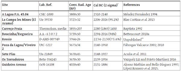
There were also settlements located in low-lying and well-irrigated areas, or in low-altitude granitic alveoli, including the examples of Poza da Lagoa/Viveiro 2, in Redondela, Pontevedra (Fábregas Valcarce 2001; 2010) and A Lagoa PA 45.04, at Toques, A Coruña (Méndez Fernández 1994; 1998). Another settlement is at Os Torradoiros, at Moaña, Pontevedra, on a spur of the gentle slope of Monte Faro de Domaio, close to a stream overlooking the Ria de Vigo estuary (Vazquéz Liz and Prieto Martínez 2016)12 (Table 1).
At almost all of these sites there is documentation of pit structures, post-holes, and small trenches, as well as some fireplaces, demonstrating that the constructions were built from perishable materials.
These are places where the pottery assemblages are well distinguished from the Chalcolithic sets, due to their shapes, decoration, and dimensions. The containers are generally larger, with shapes provided with more or less accentuated necks, S-profiles, flat bottoms, and decorations, mostly associated with plastic decoration, in particular cords. Despite revealing apparent uniformity with the interior, on the western side there are no Chalcolithic shapes or decorations, nor Cogeces-type shapes and decorations that emerged in the Northeast Iberian Peninsula.
There are no, or very few, flint and flaked stone artefacts in Galicia (Fábregas Valcarce 2001; 2010) and the rest of the northern coastal area (Bettencourt 2000).
In terms of agro-pastoral activities, this period is difficult to determine, since the syntheses on plant macrorests, due to their scarcity, seem to be from the Early Bronze Age as well as the Middle Bronze Age, a period that spans much of the 2nd millennium BCE.
Other paleoenvironmental data for the Atlantic sub-region are abundant (Ramil-Rego et al. 1998; Fábregas Valcarce et al. 2003; Muñoz-Sobrino et al. 2007; Mighall et al. 2006; Martínez-Cortizas et al. 2009; Carrión et al. 2010a; López-Merino et al. 2010a; 2012; Kaal et al. 2011) and points to a significant decrease in forest cover, which occurred throughout the Middle Bronze Age. Its cause is usually assumed to be anthropogenic, although climate deterioration could have also enhanced episodes of deforestation and erosion (Fábregas Valcarce et al. 2003; Muñoz Sobrino et al. 2005; Martínez-Cortizas et al. 2009; López-Merino et al. 2010a; Kaal et al. 2011). Nevertheless, significant regional differences have been detected (Ramil-Rego 1993; Muñoz-Sobrino et al. 2004; 2007; Kaal et al. 2011; López-Merino et al. 2012), suggesting that deforestation occurred earlier and was more intense in coastal and sub-coastal zones, as well as mainland low-to-mid altitude areas, probably due to the fact that these areas were suitable for farming or pastoralism.
The Atlantic Sub-region (Funerary Contexts)
There are various funerary contexts in the period under study, including both cremations and inhumations. Cremations, which existed in the Northwest Iberian Peninsula since the third quarter of the 3rd millennium BCE, as seen in the cist of Agro de Nogueira, at Melide, Lugo (Bettencourt and Meijide Cameselle 2009), spread to other contexts, as revealed by the urn deposited inside the Cameixa pit, at Boborás, Ourense (Parcero Oubiña 1997; Criado Boado et al. 2000), and the urns deposited in the Boucinhas pits (Bettencourt 2010a). This phenomenon also seems to occur in small cairns located in the highest areas of the coastal reliefs, such as Serra da Muna 1 and 2, at Campo, Viseu (Cruz et al. 1988).
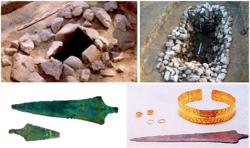
Tombs with more ambitious construction requirements, although underground, began from this period, in areas close to well-irrigated valleys. Such is the case of Vale Ferreiro 1 and 2, at Fafe, Braga (Bettencourt et al. 2005). Cists are also found near watercourses, where bodies were inhumated, revealing a more or less standardised behaviour. One can refer to those cists in which a new ‘weapon’ was deposited: a long tanged dagger or a short sword, sometimes associated with traditional metallic artefacts or with sumptuous gold artefacts. Examples include the Quinta da Água Branca cist, at Vila Nova de Cerveira, Viana do Castelo (Fortes 1908; Bettencourt 2010a), one of the cists in the Atios necropolis, at Budiños (Vasquez Varela 1980), a cist in the necropolis of Agra da Insula/Pedra Figueira/Pedra Marrada, at Carnota, A Coruña (Vasquez Varela 1980; Bettencourt 2010a), associated with a wrist guard, and the Fariña cist, at Santa Comba, A Coruña (Ruíz-Gálvez Priego 1979) (Figure 6).
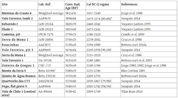
In parallel, or already in the transition from the 3rd to the 2nd millennium BCE, burials were made in flat graves, located on sloped areas and overlooking well-irrigated valleys. For example, one of the flat graves in the necropolis in the block of the former Braga post office (CTT), and one of the flat graves of the Pego necropolis – also in Braga (Sampaio 2014). The construction of small cairns is also verified, reoccupying the plateaus of the coastal mountains. This phenomenon already occurred from the third quarter of the 3rd millennium BCE, i.e. Regedoura 2, at Fafe, Braga (Pereira 2018); Illade 3 and Reboredo at As Pontes, A Coruña (Vaquero Lastres 1995); Meninas do Crasto 4, Baião, Porto (Jorge et al. 1988), and is distributed from Asturias to central and northern Portugal,13 and is evident in the transition from the 3rd to the 2nd millennium BCE. Examples include monuments such as Monte Deva 5, at Gijón, Asturias (Blas Cortina 1985); Outeiro de Gregos 1, at Baião, Porto (Jorge 1980); Serra da Muna 1 and Serra da Muna 2, at Viseu (Cruz et al. 1998); Vale de Chão 1, at Braga (Vilas Boas 2014) (Table 2). Within this dynamic, it is also important to consider the small cairn of Chã do Carvalhal 1, at Baião, Porto, where tanged daggers and Palmela points were deposited (Cruz 1992), and at the Senhor dos Aflitos, Arouca, Aveiro, where a large cist was associated with tall sub-cylindrical and truncated conical ceramic containers (Pereira 2014). The new constructions were located either close to the old megalithic monuments of the 5th/4th millennia BCE, or in entirely new areas, demonstrating an effective reoccupation of grazing lands.
This stage includes individual burials in copper mines, such as those of El Milagro, at Onís, and El Aramo, Riosa, both in Asturias, where remains of between 19 to 26 individuals were collected, respectively, and sometimes associated with mining artefacts (Blas Cortina 1996; 1998; 2003; 2005). Some belong to this period.
The Atlantic Sub-region (Adoption of Halberds in Their Different Contexts)
Another typical phenomenon of this period is the adoption of halberds by the populations of the Atlantic sub-region of the Northwest Iberian Peninsula. Although the halberd chronology may be questionable, its insertion at this period is based on radiocarbon dating available for the halberds in Great Britain, considered to be predecessors of the Irish and Carrapatas-type halberds, the latter typical of the Northwest Iberian Peninsula. According to Needman et al. (2015), halberds in Great Britain date from the third quarter of the 3rd millennium BCE, but were only adopted in Ireland, and on the Atlantic façade of the European continent, in the final quarter of the 3rd millennium BCE, between 2294-1921 BCE, the chronological interval in which we also date them in the Northwest Iberian Peninsula.
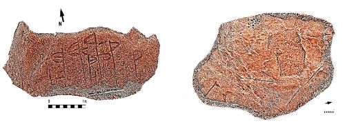
They appear to be primarily recorded in the westernmost regions of Galicia and North Portugal, where they occur in 29 outcrops (Bettencourt 2021), a very small number compared to more than 1000 with a stylistic grammar typical of Atlantic rock art (Rodríguez-Rellán et al. 2018; Bettencourt et al. 2017a). These motifs mainly appear isolated or associated with daggers of different types (sometimes of large dimensions), and with graphic elements that differ from previous imagery (Figure 7).
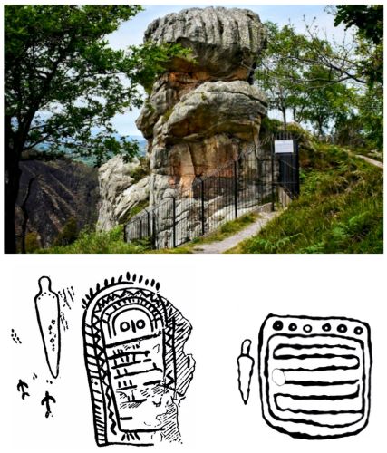
bottom left: long dagger and idoliform of Peña Tu (http://apuntes.santanderlasalle.es/arte/prehistoria/neolitico/pena_tu.htm); bottom right: idoliform figure of Outeiro do Corno, Teo, A Coruña (Fábregas Valcarce et al.2004, adapted)
In some cases, they have been recorded on outcrops with Classic Atlantic rock art motifs, probably as agents of appropriation and construction of known landscapes (Bradley et al. 1994), or as agents of reinterpretation or symbolic integration of previously significant spaces, in a new ideological order (Bettencourt 2013; 2017a). It is in this context that we find the first physical armed stelae, or engraved/painted stelae, on more or less abrupt surfaces or horizontal walls. A possible stele from this period, or reused during this period, may be the one from Boulhosa, at Paredes de Coura, Viana do Castelo, which appears to have been recorded with a kind of dagger (Bueno Ramírez et al. 2005). Other paintings and engraved examples include Peña Tu, Vidiago and Llanes, Asturias, a long dagger associated with an idoliform figure (Bueno Ramírez and Fernández-Miranda 1981), the idoliform figure of Outeiro do Corno, Teo, A Coruña, also with the representation of a dagger (Fábregas Valcarce et al. 2004) (Figure 8), and from Castriño do Conxo (Peña Santos 1979), which Bueno-Ramírez (2005: 589) considers as a panel-stele, by the inclination of the engraved outcrop and the similarity between the trapezoidal motif found there and the human face represented on the Longroiva stele.14
There are also the first deposits of metallic artefacts, composed of halberds and other copper-based metallic objects. Examples include Monte Lioira, from Leiro, Rianxo, found in the Galician coastal area and in close proximity to the Foxa Vella weapons engravings (Calo Lourido and González Reboredo 1980; Meijidde Cameselle 1989; Comendador Rey 1998), composed of daggers and halberds (Alves and Comendador Rey 2009), as well as the Sarreaus, Ourense deposit (Comendador Rey 1996) found inside a ceramic container and composed of halberds and rivets and long tanged daggers.
Mediterranean Sub-region
Data for this sub region are less abundant than for the Atlantic sub-region, but are nonetheless significant. Several settlements, walled enclosures, two funerary contexts, rock engravings, a stele, and deposits of metallic artefacts have been identified. The Castro de Santiago and Fraga da Pena enclosures, at Forno de Algodres, Guarda, were considered here, due to their geographical proximity, and because they are corridors running south–north, easily accessible from the Douro basin.
Mediterranean Sub-region (Settlements)
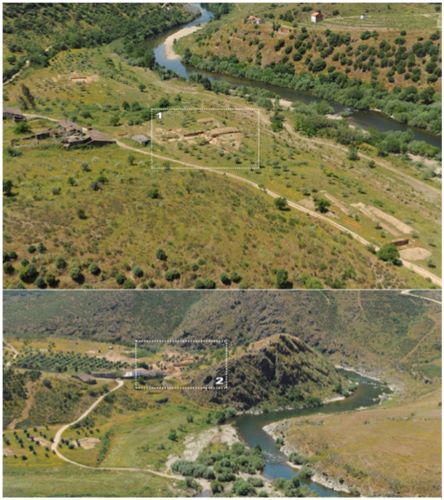
The settlements to be taken into account are: Cemitério de Mouros II, in Mirandela, located on an elevation overlooking the Tua river (Figueiral and Sanches 1998-1999; 2003); Quinta de Crestelos, in Mogadouro (Martín-Seijo et al. 2017a); and the Terraço das Laranjeiras, at Torre de Moncorvo (Gaspar et al. 2014b), located on low and well-irrigated platforms, near watercourses and implanted in areas suitable for farming (Martín-Seijo et al. 2017a) (Figure 9, Table 3). There is also the site of Fumo, at Vila Nova de Foz Côa, located in a small, irrigated and low-lying zone that has a natural spring and is protected by outcrops, at the northern end of the Almendra plateau, overlooking Ribeirinha, a tributary of the Côa river (Carvalho 2004).

With the exception of the Cemitério de Mouros II, whose upper platform was circumscribed by a dry stone wall, the others are apparently open settlements, built from perishable materials, where wood (large trunks and branches), in combination with clay, seems to have been the preferred materials. Post-holes, pits, pit hearths, hearths, sunken hut floors, small ditches, and cladding clay are common.
For the settlements where records of pottery assemblages have been published, such as the Cemitério de Mouros II and Fumo, pottery shapes and decorations from the Chalcolithic tradition have been detected, alongside other innovative forms and decorations. In Fumo there are semi-spherical and globular shapes, with a convex base, sometimes with combed or spined decorations, and with filled triangles, simultaneously with shapes of straight walls and inverted truncated-conical vessels, associated with flat-bottom bases and plastic decorations based on cords and nipple-like shapes, as well as rare Cogeces-type pottery (Carvalho 2004). In the Cemitério de Mouros II, decorative motifs and Chalcolithic-style shapes also persist, along with rare, nipple-like shapes and essentially non-decorated pottery (Sanches 1997).
At Fumo and Cemitério de Mouros there are also many flaked stone artefacts, although mostly made of local raw material, such as quartz (Fumo) or mainly quartzite (Cemitério de Mouros). Flint artefacts are rare in both cases. In Cemitério de Mouros the stone artefacts are rudimentary and there are many quern-stones and hand mills (Sanches 1997).
In terms of the activities carried out by the inhabitants living at these sites, indications of degradation of the forest cover have been detected, based on plant macrorests collected in the Cemitério de Mouros II, in the Terraço das Laranjeiras, and in Quinta de Crestelos. The forest cover was replaced by an increased number of shrub species, e.g. Cistus sp. and Erica), suggesting human activities, probably crop fields around these sites (Figueiral and Sanches 1998-1999; Martin Seijo et al. 2017a). These agricultural activities have been well documented through the discovery of quern-stones and crops at Cemitério dos Mouros II and Terraço das Laranjeiras (Sanches 1997; Martin Seijo et al. 2017a). Zooarchaeological analysis has also made it possible to detect animal husbandry and, indirectly, the existence of pastureland. This is very evident for Fumo, where domestic livestock have been identified, such as sheep and/or goats (Ovis aries/Capra hircus) and domestic ox (Bos taurus), associated with hunting activities, also indicated by the presence of wild species, such as Suidae species (Sus scrofa), red deer (Cervus elaphus), and rabbit (Oryctolagus cuniculus) (Valente 2004).
Mediterranean Sub-region (Enclosures)
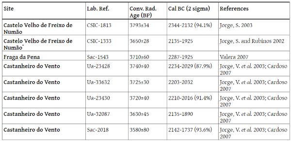
In this sub-region, walled enclosures were important devices for negotiating power during the first half of the 3rd millennium BCE, and therefore it is important to understand subsequent events (Table 4). Whereas Crasto de Palheiros seems to have disappeared in the third quarter of the 3rd millennium BCE, between 2400-2300 BCE (Sanches 2008), the settlements located more to the southeast have different dynamics.
At Castelo Velho de Freixo de Numão, in Vila Nova de Foz Côa, Guarda, located on a high spur and with broad panoramic views over the surroundings, Lopes (2019: 380-381) argues that there are no ‘secure chronological data that makes it possible to construct the internal stages of the monument during this period, nor, above all, data that indicate the precise moment when the scenography that began in the 1st half of the 3rd millennium BCE was no longer operational’. She also states that in the transition from the 3rd millennium to the 2nd millennium BCE, the monument at Castelo Velho will have become another place, articulated with new architectural constraints and certainly serving new ‘social functions’, i.e. later than at Crasto de Palheiros.
An observation of the radiocarbon dating of this site, taking into account only those results with the lowest standard deviation, enables a first stage to be established between 2885-2473 BCE, followed by another, between 2471-2293 BCE, and a third, between 2135-1925 BCE, i.e. moments that do not recover, giving the feeling that the place was being reoccupied or used at different intervals, during the second half of the 3rd millennium BCE, which culminated in the physical and symbolic reordering of the place in the transition from the 3rd to the 2nd millennium BCE.
It was during this last phase that there were structural reconstructions of the intermediate platform and the two embankments, and structures were built from perishable materials, wood and clay, and featured ditches and fireplaces; an intentionally carinated vessel was deposited. The site was only abandoned in the third quarter of the 2nd millennium BCE. Lopes (2019: 384ff) notes the virtual absence of metallic artefacts during this generic period, changes in the pottery and stone assemblages, as well as in the raw materials used in the latter, which were almost entirely locally sourced. If, on the one hand, there is a persistence of traditional pottery shapes and decorations, with a Chalcolithic background, on the other, there are containers with conical trunks, sub-cylindrical, carinated and sharp neck profiles, often with decorations based on cords and medallions, as well as Cogeces-type pottery (Pereira 1999; Varela 2000; Baptista 2003).
The walled enclosure at Castanheiro de Vento, in also Vila Nova de Foz Côa, Guarda, located on a hill offering a 360º panoramic view, presents several problems related to the objective of this paper, because the majority of excavations have not found evidence of the stratigraphic and constructive sequences of the enclosure, although this interpretation has recently changed (Muralha et al. 2018; 2019). In recent works, two levels have been identified: one prior to the construction of the outer wall of the enclosure, whose artefactual component belongs to the late 4th/early 3rd millennia BCE, and another, established by radiocarbon dating, between 2700 and 1700 BCE, too broad a time period for the resolution of the questions raised in the framework of this paper.
In this same area, the occurrence of a short tanged dagger with side lateral cut-outs (a mixed form that combines Mediterranean and Atlantic traditions) appears to be associated with the base of a stony structure that seems to restructure the space delimited by the outer wall of the enclosure, in a recurrence of a permanent construction process that Cardoso (2007) and Vale (2011) recognise as being characteristic of the Chalcolithic period. Considering that the typology of this dagger refers to the third or fourth quarter of the 3rd millennium BCE, such a process would still be active in the second half of the 3rd millennium BCE. During the 2nd millennium BCE, the most disruptive factor found at Castanheiro do Vento is the occurrence of Cogeces-type pottery fragments; however the stratigraphic context in which they occur has not been sufficiently excavated to enable an outline of the nature of the associated social activities. Whatever the content of the actions or frequency of use that occurred in the most recent phases of this enclosure, after the last quarter of the 3rd millennium BCE it was no longer active, according to the set of radiocarbon dates published by Jorge, V. et al. (2003) and Cardoso (2007), especially considering those with the lowest standard deviation.
On the border between Castile (Spain) and Northeast Portugal, the monumentalised top of El Pedroso’s enclosure, Zamora, does not appear to have continuity for subsequent periods (Delibes de Castro et al. 1995)
Further south, in Central-North Portugal, the walled enclosure of Castro de Santiago, at Fornos de Algodres, seems to have been abandoned, perhaps in the first half of the 3rd millennium BCE (Valera 2007: 100). The walled enclosure of Fraga da Pena, also at Fornos de Algodres, and located in a natural circulation corridor leading to the Douro/Muxagata stream, was only built at the end of the 3rd millennium BCE. Semi-spherical containers of Chalcolithic tradition, maritime and ‘local’ Bell Beakers vessels, and shaped forms associated with innovative decorations conveyed with the Meseta Norte (conical trunk, carinated, S-shaped or sub-cylindrical profiles, some decorated with strings and cords and associated with flat bases), were deposited, showing, as Valera (2000: 600) argues, a phenomenon of ‘compatibilisation between a tradition locally rooted throughout the millennium and the arrival of external influences… which suggest that this local space began to be integrated, in a less autarchic manner, within a dynamic that transcends it’.
Mediterranean Sub-region (Funerary Contexts)
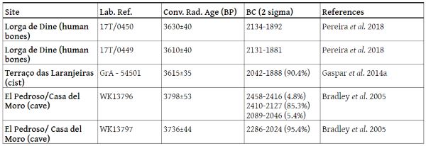
The funerary contexts for this period15 are rare (Table 5), although inhumation practices predominate. Remains of a child were found inside a cist at Terraço das Laranjeiras (Gaspar et al. 2014), and two adults in the Lorga de Dine cavity, at Vinhais, Bragança (Pereira et al. 2018). The burial at Terraço das Laranjeiras seems to have been primary (Gaspar et al. 2014), and at Lorga de Dine (Harpsoe and Ramos 1985; Pereira et al. 2018), but there are not enough data to clarify what type of deposition occurred, given the age of the excavations conducted there, the turning of the osteological materials, and the lack of any systematic study of the human remains. In the case of Terraço das Laranjeiras, the burial took place within the settlement.
It is likely that the cists of Lagares, at Macedo de Cavaleiros, Bragança, that are more than 1 m long (Alves 1975), indicate a primary inhumation practice, and, being located in an irrigated valley, can be considered from this generic period due to the associated articles found in the graves (Bettencourt 2010a).
Mediterranean Sub-region (Recorded Contexts)
A granitic shelter with engraved Schematic art (anthropomorphic and reticulated figures), located on a slope of the walled enclosure of El Pedroso, probably dates from the last quarter of the 3rd millennium BCE. Evidence was found of deposition of a Palmela point, carbonised acorns, barbed and tanged flint arrowheads, and several fragment of copper. The dates of this cavity reveal an occupation gap in relation to the end of the use of a stone structure, built on an artificial platform in front of it (2680-2458 BCE). The archaeologists responsible for the dig admit, however, that the large number of artefacts found ‘in the disturbed levels overlying this structure [suggest] that activity on the terrace may have continued for some time after the platform had gone out of use’ (Bradley et al. 2005: 132, 134). At these disturbed levels, the sherds of maritime and linear Bell Beaker pottery, Cogece-type, and flat-bottomed pottery containers that ‘increased significantly in the upper levels’, may be related to the subsequent occupation of the shelter.
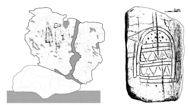
There are also three outcrops engraved with Carrapatas-type halberds: at Pedra Escrita de Ridevides 1 and 2,16 Alfandega da Fé (Santos Júnior 1963; Bettencourt 2021; Abreu 2012, Vol. IV: 110), and at Vale Figueira 11, Torrem de Moncorvo, in association with two types of daggers, one of them long (Figueiredo 2013; Silva et al. 2017) (Figure 10). The former are flattened surfaces, located in the Vilariça valley, whereas the latter is a vertical outcrop near the Figueira stream, and almost resembles a stele, i.e. designed to be seen from the front. It is also worth mentioning the halberd engraved on the slab, used as a door slab in a house in Vale do Juncal, in the parish of Abambres, Mirandela (Sanches 1994), a low altitude site near the left bank of the Tuela. The Longroiva stele, at Cruzeiro Velho, Lugar de Quintãs, in Mêda (Guarda), also dates from this period, in an area rich in mineral-medicinal waters in the Longroiva tectonic depression, a natural north–south corridor.17 In this engraving, the male character carries a halberd, a long tanged dagger/or short sword, as well as a bow and arrow (Jorge and Jorge 1990).
Although this figurative grammar is not very common in the interior zones, there is a stele at Tabuyo del Monte, in Léon, Spain (Almagro Basch 1972), in the Valtabuyo river valley, where a halberd and a long tanged dagger are associated with an idoliform motif, similar to those found on the Atlantic façade. This suggests that the Douro basin was an important route of penetration from the coast to the interior.
Mediterranean Sub-region (Other Contexts)
In the Mediterranean sub-region, there are also several deposits of Carrapatas-type halberds.18 Examples include those at Valebenfeito and Carrapatas, both in Macedo de Cavaleiros (Bartholo 1959), at Monte dos Mouros/Abreiro, Mirandela (Bartholo 1959), Alto das Pereiras, Vimioso (Bartholo 1959), El Arribanzo de Fariza, and Sayago, Zamora, near the bank of the Douro, on the Portuguese/Spanish border (López Plaza and Santos 1984-1985).19 The unmistakable association of these findings as hoards is suggested to us, for example, by the location of Abreiro, in the section between Abreiro and Quinta da Pendurada, hidden in the fissure of a rock, at the base of the south-eastern slope of the settlement of Cemitério dos Mouros, very close to a stream and discovered when a road was being built (Bartholo 1959; Sanches 1995).
Data Discussion and Interpretations: What Kind of ‘Turning Point’ Occurred between the 3rd and 2nd Millennium BCE?
Since the data have been treated differently between the two biogeographic sub-regions under analysis, it is important to discuss the two regions in an identical manner.
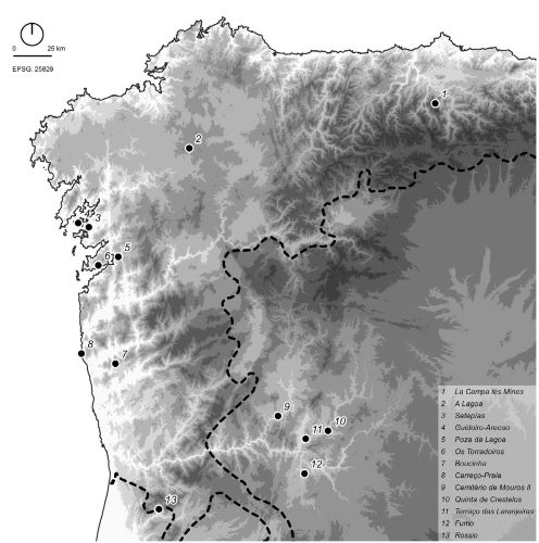
Thus, in response to the central question posed by this work, and on the basis of the available data, the Atlantic sub-region, in the final quarter of the 3rd millennium BCE, appears to have undergone a period of profound and structural change, at a social and ideological level, materialised in countless day-to-day contexts. This hypothesis has already been put forward for North Portugal (Bettencourt 2009; 2010a; 2013). This is demonstrated by the abandonment of Chalcolithic settlements, which occurred almost systematically in Portugal20 and Galicia,21 and the emergence of innovative settlement strategies. The new settlements were linked to the bottom of fertile valleys (e.g. Boucinha and Rossio), in the Atlantic sub-region, and were also associated with irrigated and fertile soils (e.g. Setepías), in mid-altitude spurs which offered easy access to watercourses and the sea (e.g. Os Torradoiros), as well as in sheltered areas, with low water accumulation, but in mountainous zones (e.g. Poza da Lagoa/Viveiro 2 and A Lagoa P.A. 45.04). Specialised settlements are still to be considered for certain activities, such as La Campa les Mines, linked to the exploration and transformation of copper ore, or the camp at Carreço-Praia, where only macrolithic artefacts were found, thought to be associated with the exploration of sea salt, based on the evaporation of sea water in removable shale sinks (Figure 11). This diversity of sites allows us to hypothesise the existence of a networked settlement, where some sites, of greater longevity, were perhaps connected with others of a more seasonal and perhaps cyclical nature, both for pastoral and mining activities, in a new structuring of the landscape that was consolidated in the first half of the 2nd millennium BCE. This seems more similar to the Cantabrian Chalcolithic period (Ontañón Peredo 2003) and deviates from the model proposed by Méndez (1994; 1998), based only on places of height, of cyclic frequency, designated as areas of accumulation and associated with a transhumance-type way of life. These accumulation areas would correspond to just one more territory to be explored in the context of a more global phenomenon of territorialisation, exploitation, and ‘conquest’ of various resources. It should be noted that the settlements that existed in the first quarter of the 2nd millennium BCE follow the same complementary settlement strategies. Examples include Lamas de Abade and Monte Calvo in mid-to-high altitude zones, and A Pataqueira, Monte de Cabanas, Sola IIa and Fraga do Zorro, connected with valleys and Areias Altas, on the coastal platform, linked to the exploration of salt and other marine resources.
On the basis of the obtained data, the same hypothesis of discontinuity can be applied to the walls and ditches enclosures of the Chalcolithic period. There was a sterile deposit, of about 20 cm, between Sola I (CA) and Sola IIa (EBA) (Bettencourt 2000), in areas where the stratigraphy has been best preserved. For Castelo de Chás, linked to the Tâmega sub-basin, there are no known pottery assemblages considered to date from the Bronze Age. In the Montenegro enclosure, a sloped area was excavated and Bronze Age pottery found, but its connection with the Chalcolithic areas of the enclosure is dubious, and its precise chronology in the context of this period is unknown. The same can be said for the ditch enclosure at Forca.22
The identity-based artefacts of day-to-day life disappear, seemingly abruptly – such as the ‘decorative’ baroque pottery known as incised/impressed Penha-type pottery, frequently associated with globular or semi-spherical shapes,23 replaced by closed forms, often in S-shaped profile, with flat bases and decorations, based on cords and nipple-like shapes under the rim, in the new settlements. There is also evidence that the communities felt the need symbolically to appropriate several significant spaces used by their ancestors, such as places traditionally engraved with Classical Atlantic rock art, alongside the affirmation and possession of new sites, through the recording of innovative and figurative symbols – such as halberds and daggers (Bettencourt 2013; 2017a; 2017b), thereby creating a first ‘armed landscape’ that gradually asserted itself in the western façade of the Northwest Iberian Peninsula, reflecting the introduction of new ‘narratives’ and new myths and the adoption of a new ideology that broke with old traditions and ancestral representations of the world, which dated back from the Neolithic and the Chalcolithic periods, and consolidated new identity-based phenomena (Peña Santos 2001: 258; Bettencourt 2013; 2017a; 2017b) that are intended to be fixed in space and recalled in the future. This indicates new symbols of power and new ceremonies, probably of a religious-magical nature, where new metal artefacts were physically or mentally manipulated, regardless of whether they were perpetrated, or presided over, by groups of warriors, ‘priests’, warriors/priests, princes, or beings with exceptional properties. This way it is possible to advance the hypothesis that places that were engraved with halberds and daggers, marked new structured places, from the end of the 3rd/beginning of the 2nd millennia BCE, around which a wide network of interconnected places was structured.
The appearance, even though incipient, of physical or engraved or painted armed stelae, seems to indicate the representation of the symbolic or real importance of characters that were socially differentiated from the community, because they had a set of weapons that gave them distinctive properties and powers.24 This indicates the emergence of societies that needed to assert themselves or give visibility to personalities with specific attributes, as well as places where they were venerated.
The phenomenon of deposition of metallic, copper-based artefacts, in areas that were not linked to enclosures, also became more common in this period, including Carrapatas-type halberds and various types of daggers. Although they are not in large numbers, they are significant because they reveal another way of ritualising exceptional and power-based objects, as well as new ways of celebrating other places in the world. Following this line of reasoning, it is worth asking whether the deposition of flat copper axes in outcrop ridges engraved with Classical Atlantic rock art, at Pedra do Lombo da Costa and Laxe das Coutadas, both in Cotobade, Pontevedra (Sobrino 1935), corresponded to another expression of this logic of mastery over old symbols, or, on the contrary, to a phenomenon of social resistance and ‘invisible’ continuity of celebration of these traditions.
There is also evidence of affirmation of new icons of power, made of copper or gold, of Atlantic expression, such as long tanged daggers or short swords, and strap gold diadems, bracelets or rings, associated with the funerary world, sometimes, in innovative combinations with more traditional power icons, such as Palmela points, short daggers and wrist guards, that existed in the Northwest Iberian Peninsula in previous periods. These associations are interesting insofar as they inscribe traditional icons in the new symbology that was being implemented.
Although individual burial by inhumation, linked with wet areas, had occurred since 2468-2332 BCE in the Atlantic sub-region, this practice became more evident and diversified in contexts of more or less complex cists, where innovative power icons were deposited, probably representing phenomena of appropriation and legitimation by the new elites, of these territories that had major agricultural potential (Bettencourt 2010a). These elites not only controlled economic activities, but also possessed magical religious knowledge, skills and abilities that enabled them to legitimise the occupation of the territory and assert themselves in a changing world (Bettencourt 2008; 2010a).
Another phenomenon that seems to develop from 2400-2200 BCE is the re-occupation of mountain plateaus, with small cairns, after a hiatus of more than 500 years, and breaking with the absence of funerary megalithic constructions that seems to have occurred during the first half of the 3rdmillennium BCE. This phenomenon accompanies the emergence of new camps or seasonal settlements in the lower slopes of hills, as Fábregas Valcarce (2010) has already defended for Monte Penide, in Galicia.
Thus, during this period, social and ideological structural changes took place, and the spaces for the negotiation of power and identity were also inverted, compared to the first half of the 3rd millennium BCE. Large community enclosures were replaced by new significant and structured places, such as places engraved with weapons or armed stelae, often near to waterlogged areas, springs, or on well-irrigated platforms, as well as sites where new ‘ancestors’ were venerated, deposited in unusual burial structures, or with unusual offerings. One example is Vale Ferreiro, at Fafe, Braga (Bettencourt et al. 2005; Bettencourt 2008; 2010a; Sampaio and Bettencourt 2018).
In the Mediterranean sub-region of the Northwest Iberian Peninsula there seems to be a dynamic that is different from that found in the Atlantic sub-region. There was greater resistance to change, and, as consequence, change occurred more slowly, and perhaps asymmetrically, between the western and eastern zones of this region.
It seems evident that there was an alteration of the Chalcolithic settlement strategies, with abandonment of settlements located in medium-altitude reliefs offering more or less dominant panoramic views over the surrounding valleys25 (with the exception of Cemitério de Mouros II), which were replaced by new settlements on fluvial terraces (Quinta das Laranjeiras, Quinta de Crestelos) or areas closer to valleys (Fumo),26 articulated with new forms of territorial control (Figure 11). But there are indicators of continuity within this process of change that must also be taken into account. In the new settlements, this includes continuation of the shapes and decorations of the identity-based pottery of the 3rd millennium BCE, alongside other formally and decoratively distinct groups, as well as the permanence of significant production of flaked stone artefacts.
Continuities also occur, for example, in the construction, during this period, of a walled enclosure (Fraga da Pena), considered to be a phenomenon of resistance by Valera (2007), and, perhaps, in the ceremonial enclosure of Castelo Velho de Freixo de Numão, where it seems that the local population started to alter, albeit slowly, the stone structure of the place. However, in other devices of collective power, from the first half of the 3rd millennium BCE, there was constructive divestment or condemnation of such power (e.g. Crasto de Palheiros and Crasto de Santiago). The depositional shelter of Buraco da Pala in Mirandela, Vila Real (Sanches 1997) was also abandoned, indicating that the reorganisation of the traditional system of land occupation was already irreversibly underway at the end of the 3rd millennium BCE, which then led to a new cultural identity phenomenon.
In funerary terms, parameters of comparison with the Chalcolithic period are difficult, given the lack of evidence for this period, although some continuities do seem to have persisted. The tradition of burial in caves continued, of which the Lorga de Dine is a paradigmatic case of continuity between the second half of the 3rd and the beginning of the 2nd millennia BCE, with burials carried out at staggered intervals over this period (Pereira et al. 2018). The same can be said for the tradition of inhumation of corpses in cists in riparian areas, which existed from the Chalcolithic period (Vale da Cerva) to the Early Bronze Age (Terraço das Laranjeiras) (Gaspar et al. 2014a) to indicate the territorial appropriation of fertile valleys (Bettencourt 2009b; 2011). Contrary to the situation in the Atlantic sub-region, no individual tombs are known emphasising the social status of certain individuals, symbolised by exceptional artefacts (perhaps with the exception of one of the cists in the necropolis of Lagares), which may be related to the lack of research into this period and the lack of radiocarbon dating of some caves with human remains accompanied by daggers, that have been considered to be older.
The phenomenon of halberds recorded in open-air outcrops, of which there are numerous examples in the Atlantic sub-region, does not find much correspondence in the interior zones, at least on the basis of currently available data, which perhaps corresponds to a phenomenon of resistance to the associated ideology. It must be admitted, however, that, at least on a sporadic basis, in areas linked to valleys (Tua, Vilariça, Figueira,27 and Longroiva tectonic depressions), similar phenomena to those found in the Atlantic sub-region also occurred, with affirmation of new spaces for the negotiation of power, distinct from those of the Chalcolithic period.
In this sub-region, these new icons of power are fundamentally found in terms of phenomena of hiding/deposition, perhaps in greater conformity with the ancestral habits of depositions in enclosures and cavities, although this practice primarily occurs in valley and land- and river-based corridors (Senna Martínez 2017) – new spaces of special importance in this new era.
Taking into account the set of changes and continuities observed in the Mediterranean sub-region of the Northwest Iberian Peninsula, the phenomenon of change between the Chalcolithic and the Early Bronze Age, essentially verified in the framework of the last quarter of the 3rd millennium BCE, is characterised by social resistance and continuities, and is assumed to be more recent than the situation found in the Atlantic sub-region.
In summary, the Northwest Iberian Peninsula, from the last quarter of the 3rd to the beginning of the 2ndmillennia BCE presents itself as a region of biogeographic and cultural asymmetries, guided by different rhythms of change, and, consequently, by phenomena of innovation and resistance, in a mosaic of local contingencies that escape the overly generalising views of some syntheses.
The ‘reality’ is certainly different from the unifying panorama proposed by Blanco González et al. (2018: 58), where this territory is perceived in the transition from the Chalcolithic to Early Bronze Age as an area of ‘relatively minor changes in the realms of settlement and where Neolithic-like28 lifestyles endured longer there and cultural shifts occurred later than in other Iberian areas’. On the contrary, the scarcity of settlements in this first stage of the Early Bronze Age,29 the tendency for the appearance of ex-nihilo settlements in low or higher areas, the alteration of pottery forms and decorative symbolism, the appearance of new icons of power and new places of negotiation of the same (more expressive on the coast), disinvestment in the construction of monumental architectures of social aggregation, and the disarticulation of the supra-regional exchange networks with the south, in substitution of a greater emphasis on the Atlantic world, seems to be implanted in the last quarter of the 3rdmillennium BCE, with all the social, ideological and economic implications that this implies, advocating the changes that were to be consolidated over the 2nd millennium BCE.
Although not so widespread, this proposal had already been defended for the Atlantic sub-region of Northwest Portugal (Bettencourt 2009; 2013). In this sense, the end of the 3rd millennium BCE in the Northwest Iberian Peninsula is a period that seems to be fragmented rather than revealing continuities, initiating a new way of life that seems to start earlier on the Atlantic façade, perhaps between 2400 and 2300 BCE, and between about 2200 to 2000 BCE in the interior.
Factors of Change
Overview
What are the reasons for these changes? The answer will not be mono-causal since economic, social and ideological change is almost always the result of an intermingling of internal and external factors. In terms of external factors, the climate change that occurred in the second half of the 3rd millennium BCE must be analysed, as well as the new genetic data and changes in exchange routes motivated by the transformations that occurred in southern societies. In terms of internal factors, the different cultural backgrounds of the two sub-regions and the forms of resistance or permeability to changes must also be considered.
Climate Change
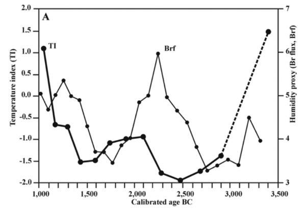
The late 4th and the 3rd millennia BCE were characterised by a period of neoglaciation. In the Northwest Iberian Peninsula this has been corroborated by geochemical data from analyses of peat bogs, that indicate temperatures between 2° C and 2.5° C lower than those currently existing (Martínez-Cortizas et al. 2009). These climatic conditions of neoglaciation (colder, drier and more windy) occurred between c. 3500 and 1500 BCE, with a constant temperature drop until c.2500 BCE (mid 3rd millennium BCE), after which there was a slight thermal increase, again interrupted by a colder period between the mid and the third quarter of the 2nd millennium BCE (between 1600-1400 to c. 1200 BCE). In terms of precipitation, there was a decrease from 2300-2200 BCE to about 1400-1300 BCE (Fábregas Valcarce et al. 2003; Martínez Cortizas et al. 2009) (Figure 12), which is, roughly, contemporary with that which has been defined as the 4.2 ka BP aridification event (Dalfes et al. 1997), around 2300-1850 BCE. This climatic event resulted from long-term orbital forcing, which led to higher summer insolation and a cool Neoglacial period in mid latitudes (Rimbu et al. 2003; Wanner et al. 2008; Magny et al. 2009), although, according to Magny et al. (2009), three environmental phases can be distinguished within this period, which makes its articulation with archaeological data (Carroza et al. 2015) complex.
This period of colder and drier conditions, led to changes in vegetation cover, confirmed by the collection of pollen data from coastal and inland areas of the Northwest Iberian Peninsula. Between 2300-2200 BCE, for altitudes between 1000 and 1600 meters, these data reveal a gradual decay of the forest cover related to climate change and forest fires (Martínez-Cortizas et al. 2009; López-Sáez et al. 2011), although in low-lying areas a greater number of disturbance and synanthropic rate indicators (such as Erica, Polypodium vulgare, Pteridium aquilinum and Cichorioideae) are found, as well as increasing presence of macrocarbons related to erosive episodes, interspersed by natural forest fires (Carrión et al. 2010a; 2010b; López-Merino et al. 2010; 2012; Muñoz-Sobrino et al. 2004; 2012; Kaal et al. 2013; Pérez-Obiol et al. 2016).
But if these conditions are well known for the Atlantic sub-region of the Northwest Iberian Peninsula, or for higher altitudes in the Mediterranean sub-region, in this case strongly influenced by glacial and periglacial erosive phases, data is lacking for the lower interior regions, where settlement occurred, and environmental and geomorphological conditions were very different from the higher altitude regions (Martin Seijo et al. 2017a). This has been overcome by anthracological studies, which, despite certain constraints, and without providing detailed description of climate change, have provided an insight into the degradation of the forest cover at a local scale (the Sabor valley), revealing an increase in shrub species (Martin Seijo et al. 2017a). This degradation was clearly higher in this Mediterranean sub-region than in the Atlantic sub-region of the Northwest Iberian Peninsula (Martín-Seijo et al. 2012; 2015).
Comparison of climate conditions and settlement conditions has already been made in detail for the 3rdmillennium BCE by Fábregas Valcarce et al. (2003), and, briefly, for the late 3rd millennium and the first half of the 2nd millennium BCE (Fábregas Valcarce 2010; Bettencourt 2013). It is now necessary to confront archaeological and climate data, more generally for the period under study. In this manner it can be seen that the rise in temperatures, which occurred after 2500 BCE, and with greater amplitude in 2300 BCE, favoured the increased settlement of higher altitude zones. This is evident in terms of camps or settlements in areas with pastoral potential, in the reappearance of funerary contexts that, after a major hiatus, once again occupied the great mountain plateaus in a generalised manner, and, also, the new wave of rocky outcrops engraved with weapons in irrigated areas of mid-to-high altitude, at least on the Atlantic coast and coastal mountains. This does not invalidate the possibility that the populations continue to occupy valley contexts, in a new reorganisation of settlement that enabled greater economic complementarity. The dry conditions, however, experienced from 2300-2200 BCE onwards, were also a preponderant factor in the occupation of high altitude wetlands (settlements, tombs, engraved loci), as well as the occupation of the bottom of valleys (settlements, tombs, hoards), wherein, in both cases, there is evidence of single tombs or exceptional deposits, indicating the importance of controlling this important resource and the existence of a macro-structure where power, in a period of extreme drought, was linked to the real and supernatural control of water. The connection to water in the Atlantic sub-region of the Northwest Iberian Peninsula is such that even today it is common to hear the expression within agricultural communities that those who have water have power.
Hence, it is likely that climate change in the second half of the 3rd millennium BCE, with an increase in temperature from 2500 BCE, and more dryness from 2300-2200 BCE, may be significantly related to changes in settlement strategies, economy, society, and ideology, as verified in the Northwest Iberian Peninsula, contrary to that which has been defended by Blanco González et al. (2018).
In the Mediterranean sub-region, whereas the increase in temperatures from the middle of the 3rd millennium BCE onwards would have enabled occupation of higher areas, such as Lorga de Dine (still located today in the so-called Terra Fria Transmontana), the existence of medium-altitude settlements, such as Cemitério de Mouros II and the maintenance or reoccupation of some high-altitude ceremonial sites. The greater anthropic pressure noted in the valleys, through anthracological analysis, suggests that the displacement of the settlement to low-lying areas, closer to watercourses, may have been more frequent than is currently known. This tendency of settlements, metallic hoards, and loci engraved with ‘armed’ weapons and stelae to be located nearer to watercourses must also be related to the period of greater dryness, once again indicating restructuring of settlement strategies, economy and society, which would have been articulated with the climate change that occurred during this generic period and with the 4.2 ka BP aridification event. It should be noted that the innovative places of power negotiation, associated with the emergence of the new ‘armed’ ideology (Vale de Figueira 11, Pedra Escrita de Ridevides, and the stelae of Longroiva) are directly linked to water and the bottom of well-irrigated valleys, which existed alongside some old and new enclosures that rise as a phenomenon of autonomy and resistance to the new power logics.
Genetic Data
In terms of external factors of change, genetic issues, such as those related to mtDNA, still need to be considered, despite the lack of discussion among archaeologists and archaeogeneticists of the dangers of ‘complex scientific data and equally complex social processes collapsed into simple narratives which echo extremist ideas about European identity, even if unintentionally so’ (Frieman and Hofmann 2019), and the problems related to the indicators used in these analyses that can lead to wide variation of data.30 In recent research, it has been found that there were population contacts between the Iberian Peninsula and North Africa that enabled miscegenation, detected between the third quarter of the 3rd millennium BCE (Camino de las Yeseras, at San Fernando de Henares, Madrid, central Iberia) and the first quarter of the 2nd millennium BCE/Early Bronze Age (Loma del Puerco, at Chiclana, Cádiz, southern Iberia), although this had limited impact and does not appear to have extended beyond the centre of the Iberian Peninsula (Gonzalez-Fortes et al. 2019; Olalde et al. 2019). In the eastern zone of the Northwest Iberian Peninsula, for example, the genetic results of the human remains found at Lorga de Dine, dated between the mid 3rd/beginning of the 2nd millennium BCE, do not indicate any genetic data of African origin (Gonzalez-Fortes et al. 2019), and therefore it may be assumed that this was not a factor of cultural change in this region. In the work by Olalde et al. (2019) it is also admitted that during the second half of the 3rd millennium BCE, about 40% of the population of Iberian descent was replaced by people of Pontic-Caspian ancestry, in almost 100% of its Y-chromosomes. This essentially occurred in the centre and north, with little impact in the south. The authors of this work, therefore, consider that the populations associated with Pontic-Caspian ancestry would, after 2000 BCE, have been associated with the origins of the Bronze Age population. The absence of genetic data for the Northwest Iberian Peninsula does not currently enable us to consider a similar development for this geographical area.
Interchange and Trade
Another factor of change that must be analysed is the role of interchange between populations, encompassing the circulation of people, goods, technologies, ideas and customs. In general, the archaeological data indicate a shift in the pattern of interchange, from the Mediterranean to the Atlantic axis, with greater expressiveness in the coastal areas, and only occasionally reaching the interior – a sub-region that seemed to maintain a greater link with continental areas or had greater autarchy.
The disintegration or collapse of the Chalcolithic system of southern communities, which began in the second half of the 3rd millennium BCE (e.g. Senna-Martinez 2007; Carroza et al. 2015; Valera 2015; Soares 2020) would have been a major factor in the decrease in interactions between the south and the northwest, but it does not explain the new dynamism in Atlantic sub-regions, already defended by some authors based on the circulation of copper and gold objects (e.g. Ruiz-Gálvez Priego 1987; Needham 2015). What motivated these exchanges?
The Northwest Iberian Peninsula is rich in gold and copper. Copper was exploited in Asturias from the first half of the 3rd millennium BCE, and in Asturias and northern Castile during the second half of the same millennium. However Blas Cortina and Suárez Fernández (2009) consider that the quantities of copper extracted would have been essentially for local consumption. But what can be considered to be local consumption? Did Asturias and northern Castile supply the copper needs of the entire Northwest Iberian Peninsula, at least after a certain moment in time? It should be noted that in many regions of Galicia and North Portugal there are copper ore deposits, including reserves of native copper, oxides and copper carbonates, capable of being used, and in quantities and abundance that could be profitably extracted at the time (Comendador Rey 1997; 1998; Van Schoor 2003). However, there is no evidence that these deposits were used. It should be noted that the copper mines at El Aramo were active until at least the middle of the 2nd millennium BCE and were not exhausted (Blas Cortina and Suárez Fernández 2009b). The same may have happened to many other mines that were explored in later periods and which it has not been possible to study in detail. It is also of note that the copper mines on Ross Island, in Killarney (southwest Ireland), ceased to be active by the end of the 3rd millennium BCE (O’Brien 1996; Lanting 2004). From this perspective it is possible that copper from the North/Northwest Iberian Peninsula, where it was abundantly mined, reached other Atlantic regions, such as Brittany or southwest Ireland,31 which were linked by ancestral contacts, since at least the Neolithic period. This could explain, for example, the appearance of Carrapatas-type halberds in hoards and the circulation of gold prototypes from Southwest Ireland found in the North/Northwest Iberian Peninsula, such as discs, lunula32 and strap necklaces, bracelets and rings.33 In this context, it should be noted that some pottery assemblages from the western zone of the Northwest Iberian Peninsula also had affinities with those of other Atlantic regions, namely with the western coast of France, Brittany and Southwest Ireland, which reveals deeper and more structural transformations than the adoption of simple metal artefacts for exchange. This is the case of the gentle S-shaped or sinuous profile pots with a cord under the rim, mainly in the neck, which are very common from the westernmost façade of Northwest Iberian Peninsula to the Ross Island copper mines.
On the other hand, the Northwest Iberian Peninsula was rich in sea salt, whose exploitation has been documented since, at least, the transition from the 3rd to the 2nd millennia BCE, from the coastal campsite of Carreço/Praia (Bettencourt 1999; 2009; 2013) and the beginning of the 2nd millennium BCE at Areias Altas, Porto (Luz 2010), an important product for exchange (Bettencourt et al. 2020).
It must also be considered that, according to Olalde et al. (2018), the arrival in Britain (from southeastern England to the western isles of Scotland) of people with large amounts of steppe-related ancestry after 2450 BCE had a long-term demographic effect, causing a replacement of neolithic populations in the Bronze Age. Therefore, it is pertinent to ask whether the Northwest Iberian Peninsula may have accommodated populations fleeing from these regions? Or was it also affected by similar population changes? The continuity of genetic studies for this area will, in conjunction with archaeological data, be important in answering these questions.
In any event, during this period the Atlantic sub-region of the Northwest Iberian Peninsula became more intensively connected with the Atlantic world, materialised through the emergence of new religious manifestations, new world views, new symbols of power, and the emergence, albeit tenuous, of individual expressions of power, which were manifested in a manner distinct from the previous period (stelae painted and engraved with weapons, cists or complex tombs with copper, long tanged daggers or short swords, sometimes with gold and copper traditional objects) that only occasionally appear to have reached the interior-most regions.
In the Mediterranean sub-region, the lack of inputs from the south led to the inability to produce or manipulate certain icons of power, such as copper artefacts, due to the absence of regions that traditionally supplied this ore. On the other hand, the products that the Northeast Iberian Peninsula could exchange, such as variscite, may have stopped being traded, which would have caused problems in the management and maintenance of power, which was not only based on agro-pastoral production (that perhaps was in crisis due to the marked dryness of the 4.2 ka BP aridification event), but was also based on the control, exploration and supra-regional exchange of this local resource. In this reorganisation, which would have occurred from the second half of the 3rdmillennium BCE, there seems to have been a greater consolidation of relations with the societies of the interior zones of the Meseta, along with certain inputs of Atlantic origin, introduced via the Douro basin. It should be noted that the León copper mine at La Profunda, Carménes, only started operating in the second half of the 3rd millennium BCE (2600-2300 BCE), which, according to Blas Cortina and Suárez Fernández (2009a), justified the intense settlement of this area during this period. This could explain the greater contacts with the Meseta, and, consequently, new dynamics and alliances that led to the adoption of new materiality, ideas and social structures.
Final Considerations
Notwithstanding this synthesis, further data regarding certain aspects of the period under analysis, in particular the internal organisation of settlements, pottery collections, livelihood strategies, radiocarbon dating and genetic data, are required before an holistic discourse can be formalised on the communities of the last quarter of the 3rd millennium BCE in the Northwest Iberian Peninsula.
However, during this period, in the Atlantic sub-region, communities were already reorganised around new scenarios, icons and performances of affirmation and negotiation of power, implying the use of old icons and the manipulation of new ones, based on alliances and supra-regional interaction networks with the Atlantic world.
For this sub-region, it is therefore possible that the transition began in the third quarter of the 3rd millennium BCE, which is a period in which settlement is unknown, and new valleys and mountain territories were ‘conquered’ – a phenomenon that is perceptible, at least in terms of funerary contexts.
In the Mediterranean sub-region, the transition period towards a new social reorganisation seems to have occurred later, between 2200-2000 BCE, with characteristics of adaptability, resilience – perhaps motivated by phenomena of autarchy – and contacts with the Meseta Norte (interior North Spain), although slow and sporadic indicators of change have been seen since 2400-2200 BCE.
The Northwest Iberian Peninsula is, therefore, a region of profound heterogeneities and cultural asymmetries, with sub-areas guided by abrupt changes and others by changes in continuities, during the second half of the 3rd millennium BCE, which results from several different factors of change and different response phenomena to common factors, and where, at least, climatic change represents one major event that is associated with more or less specific events, providing a different sequence of cultural transformations.
Appendix
Endnotes
It should be noted that Martínez-Cortizas et al. (2009), inter alia, consider that during the period of this study, due to conditions of neo-glaciation and greater dryness, the coast would have had more inlets and lagoons, thereby enabling the exploitation of salt.- With antecedents in the Neolithic era, herein assumed as a period that terminated at the end of the 4th millennium BCE. During this period, in the Atlantic sub-region of the Northwest Iberian Peninsula there were well-established links with the rest of Western Atlantic Europe. This can be seen in the circulation of techniques, ideas and beliefs that were at the basis of the construction of major megalithic monuments, in stone and earth, for the deposition of the dead and stone memorials for the living (standing stones); in some engraved or painted motifs on megalithic slabs or ceramic containers (Cassen and Vaquero Lastres 2000, Cassen et al. 2019, inter alia); in the circulation and importance of specific green rocks used for the manufacture of objects (Fábregas Valcarce et al. 2012); in the so-called Classic Atlantic rock art (according to the hypothesis defended by several authors, such as Alves 2003; 2009; Bettencourt 2013; Cardoso 2015; Alves and Carvalho 2017; inter alia). Some of these identity-based expressions would have been introduced inland, along the major rivers, such as the Douro and its sub-basins. Examples include ‘funerary’ megalithic monuments, which spread asymmetrically in the midst of indigenous groups, that were apparently distinct from the coastal areas, still poorly studied, but something which is revealed, for example, in terms of the quantities of artefacts deposited within funerary megalithic monuments and their rarity in the easternmost zones.
- Still little individualised from its Neolithic background.
- This is the closest area to the north, rich in flint raw material, which may justify the exchange with the northernmost regions (Cruz et al. 2011).
- On the right bank of the Tâmega basin, therefore more connected to the Atlantic sub-region.
- This is a unique site, with a large enclosure of about 20 m in diameter, delimited by a small ditch, in an area with scattered accumulations of materials. It was excavated in an open area (Tabarés Domínguez and Baqueiro Vidal 2005). The area of the enclosure with metope-style Penha-type pottery provided a date of 4120±40 BP (2872-2576 BCE). An area further west at a lower level, in another sector, provided a date of 3813±52 (2462-2134 BCE) with another type of pottery.
- Note the international Bell Beaker, found in the terrace in front of the Cova do Mouro, Zamora (Bradley et al. 2005), dated from 4022±27 BP (2584-2472 BCE), and the maritime and linear Bell Beaker found in the tomb of La Sima (Soria), dated from 2460-2270 (Garrido Pena et al. 2006). It should also be borne in mind that, according to Fábregas Valcarece (2001; 2010), the presence of a bell tower does not imply a rupture in the Chalcolithic sites of Galicia, such as As Forcadas and Monte dos Remédios. In fact, this has been repeated in several works by authors that synthesise this phenomenon or the communities of the 3rd millennium BCE in North Portugal, with well-contextualised data, such as Jorge, S. (1986), Sanches (1997), Barbosa (1999), Sanches (2000-2001), Jorge, S. (2002), Jorge, V. et al. (2002), Bettencourt (2011), and Lopes and Bettencourt (2017), against a certain obsession of a small number of authors, who, based on unreliable data in stratigraphic terms, systematically and uncritically attribute these pottery items found in Galicia to the Early Bronze Age.
- However, the Northwest Iberian Peninsula continues to be part of the network of Atlantic contacts, expressed now in a more tenuous way. This seems to be the case with the fragments of corded-imprinted Bell Beaker containers that occur mainly in Galicia (Suarez Otero 2011) and, to a lesser extent, in North Portugal (Jorge, S. 2002; Bettencourt 2011; Bettencourt and Luz 2013). One can refer, for example, to those deposited in the rock shelter of Arca dos Penedos, Ourense (Eguileta et al. 1993-1994); in older megalithic funerary monuments, e.g. Forno dos Mouros (Toques, A Coruña), Alto de San Cosme (Mos, Pontevedra) (Prieto Martínez 2011) and Monte dos Marxos (Rodeiro, Pontevedra) (Suárez Otero and Lestón 2005); in the presumed ‘settlements’ of A Fontenla (Moaña, Pontevedra) and As Gándaras de Budiño (O Porriño, Pontevedra) (Suárez Otero 1995; Prieto Martínez 1999) and in the enclosures of (Maia) (Bettencourt and Luz 2013), Castelo Velho de Freixo de Numão (Jorge, S. 2002) and Castanheiro do Vento (Bettencourt and Luz 2013).
- In this regard, it is important to note the existence of a considerable number of unfinished variscite beads, at the Chalcolithic level of Buraco da Pala, in Mirandela, a factor that Sanches (1997) considers is probably linked to the mining area of Ervedosa. It should also be noted that the 75 variscite beads from Vilanova de São Pedro, in Azambuja, Estremadura, primarily derive from Palazuelo mineralisations (Odriozola et al. 2013).
- Beta-365865: 4100±30.
- Which may also have been changed at some point in the 3rd millennium BCE (Fábregas Valcarce and Vilaseco Vásquez 2004).
- From a more recent period, although still considered to pertain to the Early Bronze Age, other settlements are known, in similar locations to those of the transition from the 3rd millennium to the 2nd BCE. In this case, there are settlements in areas more favourable to pastoral activities, e.g. Lamas de Abade, in Santiago de Compostable, A Coruña (Martin Seijo et al. 2017c); Monte Calvo, in Baião, Porto (Marín Seijo et al. 2012; Bettencourt 2013), those located in valleys with agricultural potential e.g. A Pataqueira, in Palas de Rei, Lugo (Martín Seijo et al.2017c), Monte de Cabanas, in Vigo, Pontevedra (Tereso et al. 2016, Martín Seijo et al. 2017b), Fraga do Zorro, in Verín, Ourense (Prieto Martínez et al. 2009; Prieto Martínez and Gil Agra 2011), Sola IIa, in Braga (Bettencourt 2000), and those on the coastal platform, e.g. Areias Altas, Porto (Luz 2010).
- The phenomenon occurred on a broader geographic basis, also expanding to the south, beyond the area analysed in this work.
- This phenomenon is also found in Cantabria, as shown by the ‘armed’ stele/orthostat of Collado de Sejos, Cantabria (Bueno Ramírez 1983; Teira Mayolini and Ontañón Peredo 2000).
- The findings of the sub-basin of the Tâmega river, in western Trás-os-Montes, were not counted, because in geographic terms they occurred in an area of Atlantic influence.
- The name means ‘the Written Stone of Ridevides’.
- Ana Bettencourt 24 de Fevereiro de 2021 09:50.
- Designation attributed by Schubart (1973).
- The closest archaeological context is a settlement with incised decoration shaped like an ear of cereal, and Boquique-type pottery attributed by Plaza and Santos (1984-1985) to the Early Bronze Age.
- We refer to the Chalcolithic settlements of Bitarados, Esposende (Bettencourt et al. 2007a; Bettencourt et al. 2007b; Cardoso and Bettencourt 2008), Covelinhos, Braga (Bettencourt et al. 2007b), Quinta do Assento, Guimarães (unpublished), and Pastoria and Vinha da Soutilha, Chaves, to the Tâmega basin (Jorge 1986). The first two were abandoned c. 2500-2400 BCE, based on the C14 radiocarbon dating that has been published (Lopes and Bettencourt 2017).
- For Galicia, without offering an exhaustive list, this situation applies to the settlements of Requeán, at Toques, A Coruña, which probably ended between 2821-2631 BCE (at 68.5%), according to the radiocarbon dating of CSIC-898: 4200±50 BP (González Méndez 1992; 2000), of Lavapés, at Cangas, Pontevedra, which probably ended between 2620-2461 BCE at (95.4%), according to the radiocarbon dating of CSIC-1532: 4000±36 (Gómez Fernandez et al. 2001; 2004), and Monte de Remédios, at Moaña, Morrazo, Pontevedra. This list only considers settlements with greater stratigraphic power, or which have been published in greater detail. In the case of Monte de Remédios, the level of pottery with pot shapes, S-profiles, flat-bottom bases and decorations, with applied cords or nipple-like shapes, certainly from the Bronze Age, is not based on radiocarbon dating, and therefore it is not possible to state that there is continuity of occupation with the Chalcolithic period, as highlighted by those responsible for the excavations (Fábrega Valcarce et al. 2007). It is therefore strange that Gónzález Blanco and Lilios (2018) claim that the site was intermittently occupied between c. 4500-1800 BCE to justify that some settlements that existed in the Chalcolithic period continued to be active in the Early Bronze Age.
- Although it has been previously argued that this enclosure could have persisted in the Early Bronze Age (Bettencourt 2009; 2010b; 2013), based on a few ceramic sherds from a stratigraphic level that cuts across a ditch built in the Chalcolithic period, it is not possible to establish continuity of occupation because this level has not been dated.
- The most recent dates for contexts of this type are probably between 2500-2400 BCE, which is taken from dates AA63065: 4046±42 BP (2680-2470, 86.8% at 2 sigma) for the settlement of Bitarados (Bettencourt et al. 2007b); from date AA63063: 3969±63 BP (2574-2436, 55.5% at 1 sigma and 2637-2286, 93.2% at 2 sigma) for the settlement of Covelinhos (Lopes and Bettencourt 2017); and the dates Beta-258088: 3980±50 BP (2576-2460 at 1 sigma and 2625-2337, 94.5% at 2 sigma) for a context with pottery of this type in the ditch enclosure of Forca (Bettencourt 2010b). However the date A6/318: 4327±93 by B-OSL (2414-2228 BC) of the base of one ditch at Forca (Valera and Rebuge 2008) may indicate a slightly more recent dating.
- Ontañón Peredo (2019) defended similar ideas for figurations of this type in Cantabria, in northern Spain.
- Examples include the settlements of São Lourenço, at Vila Pouca de Aguiar, Vila Real (Jorge 1986), Pedreira and Regadas, at Alijó, Vila Real (Teixeira 2019) and Cunho and Barrocal Alto, at Mougadoro, Bragança (Sanches 1992; Cardoso 2014). The latter was considered to mark the transition from the 3rd to the 2nd millennia BCE, but after the calibration of C14 dating it was found that it was occupied from the first half of the 3rd millennia BCE. It also has some pottery with decorations in the form of an ear of cereal, of Bouquique-type and flat bottoms, linked to Cogeces-type pottery, whose chronology is unknown but which may correspond to the second half of the 2nd millennium BCE, taking into account the date UGRA-223 of 3220±100BP (1701-1260, 93.1%), which Sanches (1992: 107) not valorise, but which is suitable for this type of material.
- A phenomenon that continues to be found in subsequent moments, as can be seen by the Middle Bronze Age settlement of Foz do Medal, at Mogadouro, Bragança (Gaspar et al. 2014b), and of Eira, at Vila Nova de Foz Côa, Guarda (Canha et al. 2018), both on river terraces near areas with agricultural potential.
- A tributary on the right bank of the Sabor.
- The authors consider that a Neolithic way of life is maintained in the Chalcolithic period.
- A fact that can also be related to either erosive phenomena in high altitude areas or to sedimentation phenomena in the valleys, where many of these places seem to have moved, making it difficult to perceive without excavations.
- One example is the possible impact of a migration during the Mesolithic-Neolithic transition on the European gene pool that has been a controversial subject for many years (Brandt 2017: 38-44).
- The confirmation of this hypothesis implies analysis of isotopes that compare data between multiple copper resources and copper objects.
- These objects, in particular gold lunulae, are very common in Southwest Ireland, where they are considered to be an Irish innovation dating back to c. 2200-2000 BCE, according to Taylor (1970; 1980).
- The spatial distribution of these objects, from the coastal areas of the Iberian Peninsula to the French Atlantic coast (Blas Cortina 2013b), mainly in Brittany and Vendée (Briard 1965), do not provide arguments to help with their place of origin (Suaréz Otero 1991).
See Bibliography at source
Chapter 2 (12-48) from Between the 3rd and 2nd Millennia BC: Exploring Cultural Diversity and Change in Late Prehistoric Communities, edited by Susana Soares Lopes and Sérgio Alexandre Gomes (Archaeopress, 04.01.2021), published by OAPEN under the terms of a Creative Commons Attribution-NonCommercial-NoDerivatives 4.0 International license.

