George III never visited Italy. Instead he collected prints, drawings, and guidebooks enabling him to travel virtually to antiquity’s greatest architectural and artistic sites.

By Dr. Mercedes Cerón
Cataloguer, King’s Topographical Collection
British Library
A large number of views and maps in the King’s Topographical Collection correspond to locations that were once linked to the Grand Tour.[1] Visiting the settings associated with the classical authors they had studied was considered an important ‘part of the education of the aristocracy and gentry in 18th century of Europe – principally (though by no means exclusively) of the British Isles’.[2] Moreover, travelling to Italy was regarded as an opportunity to purchase antiquities and works of art that would show the traveller’s improved taste back at home. France and Switzerland were also part of the journey, which could be extended to Germany and the Netherlands. In the early 19th century, Spain, Portugal, Greece, Turkey and Northern Africa became other popular destinations for Grand Tourists.
George III was not much of a traveller.[3] Unlike his younger brother, the Duke of Gloucester, who bought and commissioned a considerable number of works of art during his trips in the 1770s, the King never visited Italy. His purchases of Italian prints and drawings from the collections of Cardinal Albani and of the British consul in Venice Joseph Smith were made through agents, probably on the advice of his mentor John Stuart, third Earl of Bute (1713–1792).[4] However, the King’s collections included copies of the maps and guidebooks that most Grand Tourists would consult on their travels, as well as examples of the single-sheet prints and albums of views they would bring back as souvenirs. These materials could help recreate at least certain aspects of the Grand Tour experience in the calm and seclusion of the King’s own library.

Equipped with their guidebooks and maps and accompanied by their tutors, most Grand Tourists would cross the Channel and travel through France and part of Switzerland before reaching Italy. They would spend some time in Paris, where they practised the language by mixing with local society and, depending on their personal interests, visited the tailors, the theatres and the shops and attended lectures and scientific demonstrations.
In this ‘townscape of power, activity, order and style’, British travellers could admire examples of recent and contemporary French architecture, such as those depicted in the Vues pittoresques des principaux édifices de Paris by architect and theorist Jean-Nicolas-Louis Durand (1760–1834).[5] Durand included in his series the main sights of Paris, such as the Bastille, Les Invalides, Notre-Dame and the Louvre, but he also showcased the work of fashionable Neoclassical architects like Étienne-Louis Boullée (1728–1799) and Claude-Nicolas Ledoux (1736–1806). Examples of their designs can be found in a series of exquisitely drawn anonymous views, elevations, plans and sections of Parisian private houses in the King’s Topographical collection, probably produced in the 1780s–1790s (see, for instance, Maps K.Top.124 Supp.fol.11.).

George III could also follow on the steps of earlier Grand Tour travellers by leafing through the pages of the two volumes of prints and drawings compiled by the antiquary Walter Bowman (1699–1782). Bowman travelled in France and Italy as the tutor of successive pupils in the 1720s, 1730s, 1740s and 1760s. His volume of Italian views is dated 1739 (Maps 7.TAB.15.), while his French views were bound separately in about 1766 (118.c.2.). The latter are mainly 17th-century etchings by Israel Silvestre and Adam Perelle depicting the main sights of Paris and the gardens and châteaux in its vicinity. A large number are devoted to Versailles, but Fontainebleau, Saint-Cloud, Chaville, Saint-Germain-en-Laye and Noisy-le-Roi are represented as well.
Some of the drawings Bowman himself made show the ideal Grand Tourist in action. Two sketches in red chalk of the countryside around Berry-au-Bac (Aisne) are described in the table of contents as ‘taken from the camp of Sabinus’, with a reference to the corresponding passage in Julius Caesar’s Bellum Gallicum (118.c.2., pp. 174–175). The supposed site of Caesar’s camp near Reims is the subject of a map, also in red chalk, annotated with Bowman’s calculations of distances (p. 176). Moreover, Bowman’s travel sketching in France resulted in two watercolours that evince his interest in Gallo-Roman engineering. With the same text in hand, he observed and drew the stonework of the Aqueduct of Traslay in Bourges (p. 181) and the composition of the walls of Bourges ‘as described by Caesar in his Comment. Lib.7.’ (p. 182).

The majority of Grand Tourists would travel from Paris to Lyon and then to the Franco-Savoyard border and across the Duchy of Savoy, although some preferred to take a detour via Geneva.[6] In the second half of the 18th century, their experience of the Alpine scenery would have been mediated by their readings on the Sublime. Later in the century, widespread fascination with Alpine glaciers prompted Swiss publisher Christian von Mechel (1737–1817) to publicise Horace Bénédict de Saussure’s ascent to Mont Blanc in two beautifully coloured etchings (Maps K.Top.76.77.c. and Maps K.Top.76.77.d.). The King’s Topographical Collection includes a number of views of the most popular Alpine spots frequented by travellers, such as the Mont Cenis pass and the Mer de Glace. They are signed by Geneva-based artist Carl-Ludwig Hackert (1740–1796), whose brother Jacob Philip worked in Rome and Naples, where he specialised in painting views aimed at the Grand Tour market. The latter’s paintings and drawings were often reproduced in printed series, such as the Vues des environs de Rome (1781, see Maps K.Top.82.1.).

Some travellers, wary of the inconvenience and length of the journey through France and of the dangers involved in crossing the Alps, would choose to sail from Britain to the port of Livorno (Leghorn) on the western coast of Tuscany. Although the journey by sea, which could take up to three months, was not exempt of risks, this was the preferred route to send back artworks acquired in Italy.[7] Livorno’s busy port is the focus of eight views in George III’s collection. Their dates range from the heyday of the Grand Tour in the 1750s, to 1816, when travel in the Mediterranean was resumed after the Napoleonic Wars.

Once in Italy, Rome was the main destination for Grand Tour travellers. As Rosemary Sweet notes, navigating the city successfully and productively required not only some preparatory reading, but also the services of a guide (cicerone) or an antiquarian like the already mentioned Bowman.[8] Ciceroni were eventually replaced by popular ‘guidebooks’ like Giuseppe Vasi’s Itinerario istruttivo… di Roma (1763), which could include recommendations on the ‘traditional tourist purchases of prints’.[9] George III’s collection contains many 18th-century views of Rome of the kind that would appeal to Grand Tourists. A small album of etchings after Giambattista Piranesi’s evocative vedute (119.b.18.) would have been regarded as both an attractive and practical (because of its size) acquisition. Equally common additions to Grand Tourists’ luggage were the hand-coloured views published by Giovanni Volpato (1735–1803). Volpato’s links to the Grand Tour market were not limited to his role as a printmaker and publisher of series like the Vues de Rome et de ses environs (1780), his views of the interior of the Palazzo Farnese and the prints after Raphael’s Vatican frescoes (Maps K.Top.81.43.g., Maps K.Top.81.69.a. and Maps K.Top.81.61.n-w.). He was also involved in the excavation of antiquities and in dealing in both originals and replicas of Roman sculptures.[10]

Other popular destinations outside Rome and Florence were Venice and Naples. The sparkling views of Venice painted by Canaletto were greatly admired by British Grand tourists who, depending on their means, would acquire either the originals or high-quality prints.[11] The King owned several paintings of Venice and Rome by Canaletto from the collection of Consul Joseph Smith, as well as a large number of related prints. Antonio Visentini’s album of preparatory drawings and prints after Canaletto’s works for his Prospectus Magni Canalis Venetiarum (1735–1742), now in the British Museum, was once in George III’s collection.[12] Three volumes of drawings of Venetian palaces entitled Admiranda Urbis Venetæ (1730–1740) and later editions of and copies after Visentini’s prints can also be found in the King’s Topographical Collection (71.i.1. to 71.i.3.).

Travelling south to the Kingdom of Naples became an integral part of the Grand Tour mainly after the discovery of Herculaneum and Pompeii in the 1730s–1740s.[13] Visitors attracted by their ruins could also indulge their scientific interests by watching the frequent eruptions of Vesuvius, famously documented by Sir William Hamilton and Peter Fabris in their Campi Phlegraei (1776). Almost 20 years later the volcano remained an object of wonder, depicted in two anonymous nocturnal views in the King’s Topographical Collection, possibly intended as souvenirs (Maps K.Top.83.61.i. and Maps K.Top.83.61.k.).

On their return journey from Italy, some travellers chose to visit Austria, Germany and the Netherlands. These alternative routes became increasingly popular in the late 18th century, at a time when the type of Grand Tour traveller was beginning to change and its focus to broaden. A number of albums in the King’s collection relate to the twilight of the Grand Tour and to the origins of tourism as we understand it today. They were all conceived, produced and marketed around the idea of travel by Vienna-based publisher Domenico Artaria (1775–1842), whose Italian family had been dealing in prints since the 1770s. In Johann Jacob Strüdt’s Salzburg (Maps 7.Tab.64.(3.) or Karl Postl’s Bohemia (Maps 7.TAB.38.), travellers visit not only lakes, mountains, churches and castles, but also modern spas and other health resorts. Johann Ziegler’s 1798 German views reproduce a journey along the Rhine for an audience interested not only in history and architecture, but also in any signs of industrial and technical progress (Maps 6.Tab.12.). Attractively coloured and illustrated by skilled printmakers, their travel accounts were probably published with armchair travellers in mind.


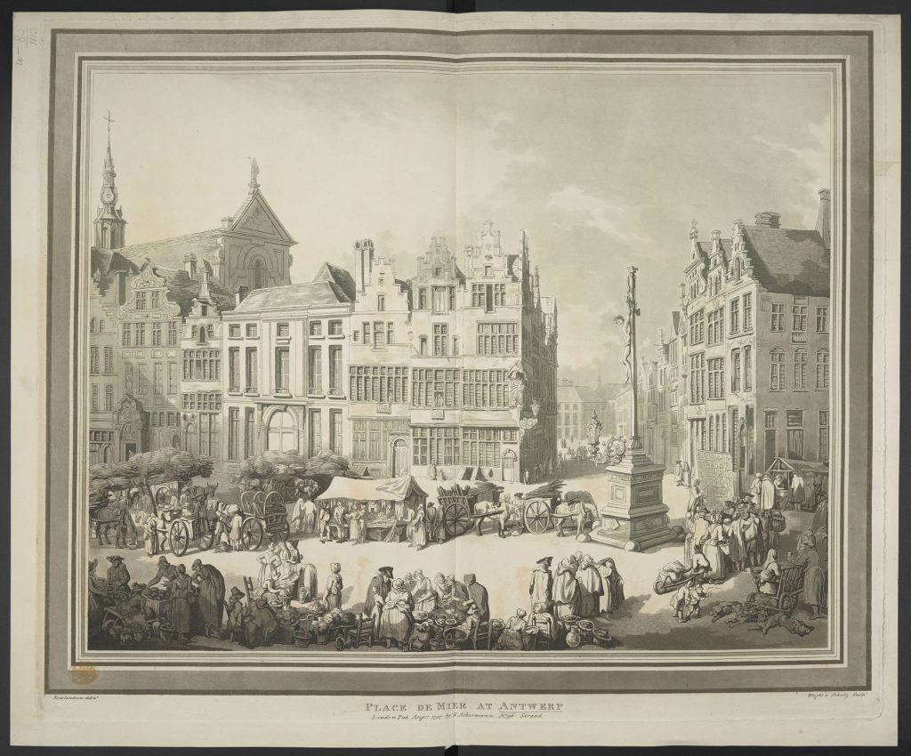
Professional artists were another type of travellers associated with the Grand Tour. Most artists travelled to France and Italy in order to see the masterworks they were expected to emulate. But some, like the caricaturist Thomas Rowlandson (1757-1827), were also in search of new experiences and subjects for their works. Rowlandson, who visited Paris on many occasions, went to Rome in about 1782 and to the Low Countries and northern Germany in 1791-1792.[14] His view of the Place de Meir in Antwerp shows a combination of picturesque architecture, casual mixture of the sacred and the profane and local colour likely to match most travellers’ expectations (Maps K.Top.103.58.n.).

This quick overview has been selective in its attempt to explore how the collection could replicate the Grand Tour in the King’s library. But the views and maps in the Topographical Collection also cover other Italian regions and cities that have not been mentioned in this essay. The same applies to the rest of Continental Europe. Despite a noticeable over-representation of works made in the second half of the 18th-century, their chronological scope goes beyond the Golden Age of the Grand Tour, traditionally identified with the years from 1764 to 1796.[15] This richness and variety allows for many other alternative ‘tours’ and virtual wanderings.
Notes
- Peter Barber estimates that ‘no less than about 33% [of the collection] is taken up with France, the Netherlands, Germany, Italy, and Switzerland which were particularly associated with the Grand Tour’ (see Peter Barber, ‘Royal Geography: The Development and Destiny of King George III’s Geographical Collections’, p. 3).
- Francis Haskell, ‘Preface’ to Andrew Wilton and Ilaria Bignamini (eds.), Grand Tour: The Lure of Italy in the Eighteenth Century (London: Tate Gallery Publishing, 1996), p. 10.
- ‘One of the remarkable features of George’s way of life was his comparative lack of interest in travel’, see Cannon, John. “George III (1738–1820).” John Cannon In Oxford Dictionary of National Biography, edited by H. C. G. Matthew and Brian Harrison. Oxford: OUP, 2004. Online ed., edited by David Cannadine, May 2013. http://www.oxforddnb.com/view/article/10540 (accessed November 21, 2016).
- See Barber, p. 9, and Jane Roberts (ed.), George III & Queen Charlotte: Patronage, Collecting and Court Taste, (London: Royal Collection Publications, 2004), p. 157.
- Jeremy Black, France and the Grand Tour (Basingstoke: Palgrave Macmillan, 2003), p. 4.
- Jeremy Black (2003), pp. 37–38.
- Eleanor Hughes, ‘Trade and Transport: The Westmorland in Context’, in M. D. Sánchez-Jáuregui and S. Wilcox (eds.), The English Prize. The Capture of the Westmorland, An Episode of the Grand Tour (New Haven and London: Yale University Press, 2012), p. 33.
- Rosemary Sweet, Cities and the Grand Tour: The British in Italy, c. 1690-1820 (Cambridge: Cambridge University Press, 2012), p. 101.
- Sweet, ibid., p. 105.
- Giorgio Marini, ‘Giovanni Volpato e l’Opera di Traduzione’, in Giovanni Volpato, 1735–1803 (Bassano del Grappa: Ghedina & Tassotti Editori, 1988), p. 20.
- For the paintings, see Jane Roberts (2004), pp. 169–174.
- Maps K.Top.78.65.e. (now BM 197*.d.7.).
- Sweet (2012), p. 165.
- Hayes, John. ‘Rowlandson, Thomas (1757–1827).’ John Hayes in Oxford Dictionary of National Biography, edited by H. C. G. Matthew and Brian Harrison. Oxford: OUP, 2004. Online ed., edited by David Cannadine, January 2008. (accessed November 23, 2016).
- Ilaria Bignamini, ‘The Grand Tour: Open Issues’, in The Lure of Italy, p. 33.
Originally published by the British Library under the terms of a Creative Commons Attribution 4.0 International license.


