Before writing, cities, and states, prehistoric Greece reveals deep human adaptation, migration, ritual, settlement, and cultural transformation across thousands of years.

By Dr. Jack L. Davis
Carl W. Blegen Professor of Greek Archaeology
University of Cincinnati
Introduction
An expansion of very small Mycenaean settlements in early phases of the Late Bronze Age reflects the existence of social and political structures that herald the emergence of the Mycenaean state. My approach in this chapter is somewhat different; it is an exercise in model building by analogy, of a sort promoted by New Archaeologists. I draw on lessons learned from a decade-long “vacation” from prehistory, when I became fascinated with Mediterranean historical geography of the seventeenth and eighteenth centuries A.D. I begin with a brief history of post-antique Pylos and hint at the richness of the post-antique archaeological record that remains to be explored. Next I suggest ways in which an integration of text and material culture can help to disentangle the various components contributing to the restructuring of patterns of rural settlement. A full-scale assault on Ottoman archives in Istanbul opened the road to a very detailed understanding of the countryside of Pylos and was particularly informative in regard to estates occupied by sharecroppers. Income was extracted from these estates to support Ottoman officials. I suggest that a similar system of wealth extraction from benefices existed in the Early Mycenaean period and that elites grounded their power in local agricultural production.
As a student in the early 1970s, I became curious why it was so difficult to obtain detailed information about times when Greeks labored under the “Ottoman yoke,” as it was frequently called.
I remember being told by several professors that this was because the Turks had destroyed primary records when they left Greece during the Greek Revolution.
I learned later that that explanation was a myth. The Ottomans were meticulous bureaucrats, and copies of all significant documents were archived in Constantinople. Even within Greece itself, Ottoman administrative archives have survived.1 Our ignorance of the period instead reflected a lack of interest on the part of his-torians of Greece and Turkey. On the one hand, the national project of the Greek state emphasized ties with antiquity, secondarily with the Byzantine Empire, not Turkey.2 On the other hand, Turkish scholars were not much concerned with what was a minor part of the Ottoman Empire. As a consequence, for many parts of Greece, the centuries prior to the 1821 War of Independence have long been more prehistoric, figuratively speaking, than the Bronze Age.
Post-Classical Archaeology and Pylos
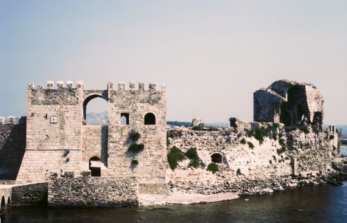
The province of Messenia fell to Western European crusading knights, as did most of the Peloponnese, after 1204 A.D., in the wake of their brutal con-quest and sacking of Constantinople, capital of the Byzantine Empire (which the Latins held until 1261).3 The exception was its southwestern projection with the fortresses of Koroni and Methoni on either side, claimed by Venice as its “eyes” in the Levant, the eastern Mediterranean (see figure 1). Not long after the Ottoman conquest of Constantinople in 1453 A.D., at the hand of Sultan Mehmed II, the area of Pylos passed from Latin to Ottoman control in 1500 A.D. Then, except for an interruption between 1685 and 1715, when Venice occupied the entire Peloponnese, and a few years in the late eighteenth century, when Russian forces invaded, Pylos remained Ottoman until 1828.4
In recent decades Greek and foreign scholars have at last begun to mine Otto-man archives in order to write regional histories. At the same time, there has been a greater emphasis on the archaeology of medieval and Ottoman Greece. These periods are now emerging from darkness, sometimes in surprising ways. Undiscovered physical remains may, in fact, be hiding in plain sight.
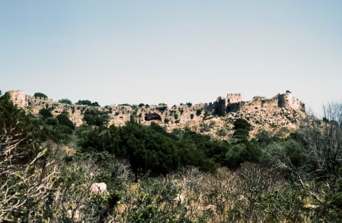
In 2011, before Sharon Stocker and I rented a house in the town of modern Pylos, we regularly stayed in a small villa in the seaside village of Yialova, fifteen minutes by car from the Palace of Nestor and forty minutes by foot from the Latin stronghold of Old Navarino (see figure 2). The castle of Navarino was built at the end of the thirteenth century A.D. by Nicholas II of Saint Omer—an heir to those knights who had conquered the Peloponnese. One morning Sharon went jogging before work while I drank my morning coffee on the veranda of our villa. Her usual course ran along the north shore of the Bay of Navarino to the foot of the castle and back. That particular day Sharon casually announced on her return, “I found the aqueduct that supplied water to the castle.”
“Right,” I said. “Sure you did”—since I wasn’t even certain that the castle had had an aqueduct. At least I then knew of no published account that described one.
What Sharon had noticed was a line of trees and brush defining a low, linear earthwork. I saw it with my own eyes that same afternoon. She was absolutely correct. I could also follow its course on satellite imagery once I knew where to look. In 2012, Michalis Kappas of the Greek Ministry of Culture’s office in Kalamata and I were able to verify in only a few hours that a stone channel was still preserved beneath the earth and the thick vegetation covering it.
Research in the Gennadius Library of the American School of Classical Studies in Athens later revealed that Sharon was not first to have seen the aqueduct.5 Captain Smyth of the British navy in 1823 marked its course with a dotted line on a map.6 An earlier Venetian map showed that more of the aqueduct was preserved in the later seventeenth century, but even then it was no longer in use. The great Ottoman traveler Evliya Çelebi also wrote about the castle in the seventeenth century:
As you go down to the shore by the harbor, there is a huge arched structure which is supposed to have brought water in from the rocks and mountains to this castle of Navarino, but it has fallen into ruin in many places with the passage of time, and because they have not rebuilt it, the water no longer flows.7
How old is this aqueduct? Because of its stone, rather than brick, construction, it likely predates the Ottoman conquest of 1500 A.D.
Discoveries of this sort, coupled with the results of intensive survey and augmented by the research of documentary historians, can supply exactly the sort of information we need to understand medieval and early modern Greece at a local level. Historical geographies of these periods can also provide analogies helpful for interpreting land-use patterns in the prehistoric past, such as the hierarchy of settlements first established in the Pylos area in the Early Mycenaean period.
Post-Classical Settlement Patterns and Dispersed Residence
My serious interest in the post-antique history of Greece began in the early 1980s when I was co-directing the intensive surface survey on Kea.8 That project was designed as a follow-up to John Cherry’s intensive survey of Melos. In the course of our fieldwork on Kea, there were many surprises, but one stood out: we could not recognize medieval and early modern remains—although texts testified to the island then having been occupied. We hypothesized that in those periods nearly everyone on the island had lived in the capital, which lay outside the area we investigated.
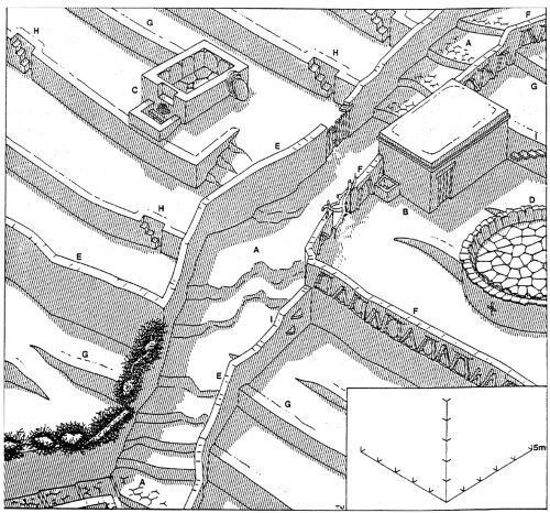
On the other hand, remains from the nineteenth century were bountiful. Nearly the entire landscape of Kea was packed with stone terraces, field boundary walls, and single-family farmhouses, many still occupied in the 1980s (see figure 3).9 These small houses were roofed with massive schist slabs, covered with earth that was renewed regularly and hard-packed with column-like stone rollers. Here was a dispersed landscape, more like Apple Creek than any other I had yet experienced in Greece.
Published literature helped very little in understanding the absence of evidence for a dispersed pattern of settlement prior to the Greek Revolution of 1821, but “gray literature” did.10 A nineteenth-century schoolteacher, Konstantinos Manthos, had written a history of Kea, not published in his lifetime, but there was a manuscript copy in the library of the British School at Athens.11 Manthos’s text had later been liberally plagiarized by Ioannis Psyllas, also a schoolteacher, who published his own work in 1920.
Psyllas appended transcriptions of Ottoman Greek documents to his history, written in a hodgepodge of unsophisticated Greek, infiltrated by Italian and Turkish vocabulary, everything stitched together with unschooled grammar. Many are last wills and testaments, dictated stream-of-consciousness to a notary by illiterate clients. They were difficult to read. Challenge accepted!
Eventually, I discovered that these documents would help me understand the nature of the agricultural system on Kea prior to 1821. Rights to graze animals and to cultivate fields had been separable. A few elite families controlled large parcels of land, demarcated by long stone walls still distinguishable in the 1980s. Under such a socioeconomic system, it was impractical for farmers to establish isolated, single-family farmsteads.12 For that strategy to make sense, they would have had to hold exclusive cultivation rights in contiguous parcels of arable land—which they did not. Also working against a pattern of dispersed residence were complex systems of partible inheritance, according to which ownership, even of individual trees in a field, might be bequeathed to different individuals.
What changed after 1821? What factors then facilitated the establishment of the many isolated nineteenth-century farmsteads that we found in our survey? The answer lay in social and economic developments that followed in the wake of the War of Independence. The elite who held large estates under the Ottomans left Kea to jockey for power and prestige in Athens, the new national capital. Many of the poor also departed to seek employment there.
A veritable agricultural revolution gained momentum, as formerly disem-powered farmers who stayed on Kea acquired landholdings under the Greek democracy. A vital land market resulted, making it possible for farmers to amass contiguous holdings, such that it became a viable economic strategy for them to live amid their fields in isolated farmsteads. An intricate system of stone-paved paths mitigated the disadvantages of living outside the capital of the island. The dispersed pattern of early modern settlement that we had observed resulted, it seems, from a complex interplay of social, political, and economic factors.
The relatively recent identification of a seventeenth-century Ottoman tax registry in Istanbul has confirmed the existence of a highly nucleated settlement pattern on Kea prior to the Greek Revolution: aside from several monasteries, everyone did live in a single town.13
In field projects subsequent to Kea, we devoted even more effort to studying the history and archaeology of post-antique Greece, partly from a desire to understand fluctuations between nucleated and dispersed patterns of settlement. In the 1980s at Nemea, we mined the archive of Antonio Nani, an early-eighteenth-century Venetian governor of the Peloponnese, and also studied Ottoman cadastral registers in Istanbul (censuses and surveys of property compiled for the purpose of taxation).14
The Economic and Social Geography of Pylos
By the time we came to Pylos in the early 1990s, an even more comprehensive study of post-antique periods seemed desirable and viable. Cadastral information from the fourteenth century A.D. had already been published, drawing from the archives of Niccolò Acciouoli, a Florentine banker who owned property in the area. Information was also readily available for the period 1685–1715, when the entire Peloponnese was part of Venice’s Stato da Màr.15 But we also wanted to learn about the Ottoman occupation.
The accounts of Western European travellers give the impression that the area was nearly deserted then and have long deceived scholars into thinking that the Ottoman administration in Greece here and elsewhere was so harsh that Christian villagers took refuge in the mountains, moving as far away from centers of political power as possible. The travelogues of the English classical archaeologist and illustrator Sir William Gell would seem to support such an idea.16
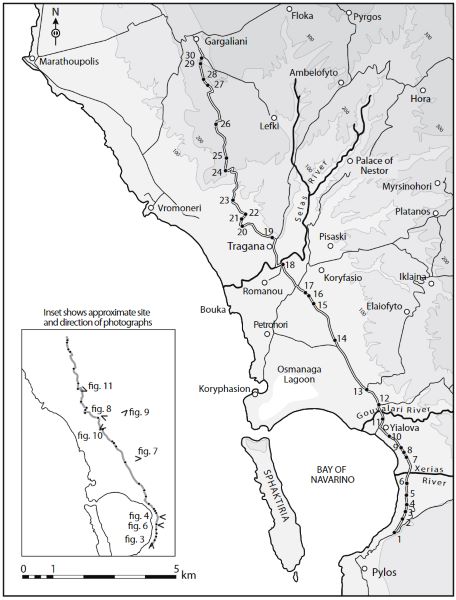
Gell has long been considered one of the most observant of Westerners who travelled in Greece in decades immediately prior to the Greek Revolution. His published itineraries record times elapsed between one landmark and the next, visible along the routes he travelled. Since Gell tells us how long (in minutes) his total journey through the Pylos area lasted, we can approximately locate each place he mentions (see map 1).
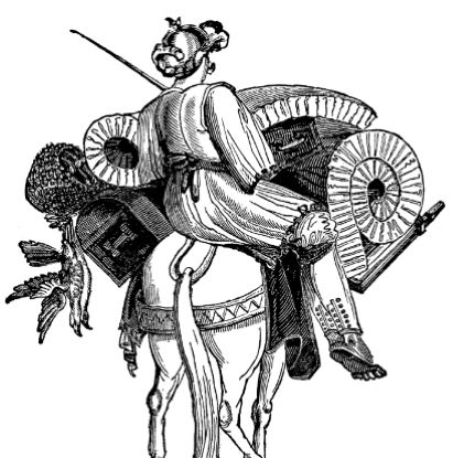
The speed that Gell travelled varied, of course, depending on the terrain (see figure 4). He himself makes this point when he describes the hardships of riding on horseback across a Greek plain
when it has been soaked by the autumnal rains; and the short herbage beginning to spring up in the winter renders it necessary for the traveller to attend to his own involuntary agitations, while the luggage-horse, after a thousand slips, and as many recoveries, almost invariably puts a stop to further progress for a short time, by receiving a desperate fall after a slide of several feet and a succession of unavailing struggles.17
Gell’s picture of the human landscape in the last century of Ottoman rule is, indeed, a bleak picture, and it would be easy to surmise that the lowlands around Pylos were desolate. In the course of a trip that lasted more than five hours, he did not report seeing a single person.
It is likely, however, that Gell’s literary style was influenced by the Europeans in whose footsteps he followed. A countryside deserted by its Christian population had become a trope. Susan Sutton has demonstrated just how formulaic the accounts of Western visitors to Greece can be: themes of desertion and isolation were maintained consistently in narratives of the nineteenth century that described the Nemea valley—despite documentary and archaeological evidence that the land was inhabited and extensively cultivated.18
Gell’s general distaste for ordinary farmers is also well-known, as is his preference for the Europeanized Greek upper class. Despite his frequent reference to the mundane (for which he was sometimes mocked by reviewers of his books), he was after all a scholar, a Cambridge graduate engaged in debates about the authorship and historicity of the Iliad and Odyssey. He was also a leader in the Society of Dilettanti (founded in 1732 as a dining club for British elite who had been on the Grand Tour). Ancient authors, notably Pausanias and Strabo, were his guides and, no doubt, averted his pen from aspects of Greece that he considered irrelevant to antiquity.
Ottoman tax registers tell a very different story from his. They and also the Frankish and Venetian cadasters make it clear that farmers were dispersed throughout the Pylian landscape in very small communities, even on isolated farms that remained viable over centuries. Finding the Ottoman documents was not difficult, but interpretating them was not easy. The Dutch scholar Machiel Kiel has described how Ottoman cadasters were composed:
A census commission headed by a Census Master (Emin) and a Scribe travelled throughout the land, visiting all localities in existence. They were assisted by the Ottoman Judge (Kadi) of the district in question and by the members of the Ottoman cavalry, the sipahis, who lived in or near the village(s) allotted to them. The Kadi had to bring copies of the local records, the villagers were summoned to show their documents and to give verbally an exposé about the manner in which the taxes were hitherto collected. The entire village population, headed by the priests and the village notables, had to appear before the commission and all married men and the unmarried boys from 13 years upward were written down with their name and patronym, and, if they had one, also with their family name.19
The Ottoman administration was mapless, and when my first European ancestors came to Ohio in 1814 and purchased land delimited by surveyors, Greece was still part of the Ottoman Empire. Once a Greek central government had been established, systematic records of land ownership were also kept, but, even then, the spatial extent of agricultural property was not indicated on maps. It has, in fact, been in only the past couple decades that Greece has produced plat books, supported by a massive infusion of cash from the European Union. Disputes over boundaries of fields were previously negotiated between farmers, mediated by special agricultural police. Such a system obviously made it very difficult for the Greek state to protect its claims to property inherited from the Ottoman state, and private encroachment on state lands was a perennial problem.
An absence of maps does not, of course, mean that the Ottoman Empire was unconcerned about levying taxes on land wherever possible. Quite the contrary. Its cadastral registers painstakingly tracked at the village, town, and city levels the amount of land worked by residents in a community as well as its productivity—and thus amounts owed to the state.
Maplessness was not our only challenge. Another catch was the shorthand script used by Ottoman scribes: for example, vowels were not indicated and diacritical dots that distinguish similarly written consonants were generally omitted: a b and a p can look the same. None of this is a serious problem if you know in advance what a text is meant to say, but it is a different matter when what interests you are place names foreign to Turkish.
A scribe might choose to translate a Greek name into Turkish in one part of a document but elsewhere to transliterate it: for example, the Greek Lykovouni (“Wolf Mountain”) could appear as Likovun or its calque Kurd Dağ. In addition, everything is complicated by the fact that many places were renamed between the sixteenth and seventeenth centuries and again in the nineteenth century: a settlement near Pylos that is today called Koryfasion was known as Osman Ağa or Büyük (big) Pisaski to the Ottomans, and to Venetians as Pisaski Grande.
As a component in our research program of the 1990s, we published one large part of a Turkish tax document—its text registered in 1716, less than a year after the Ottomans had recovered the Peloponnese from Venice.20 The cadaster is written on paper, each page of text about 15 cm wide. Twenty-three pages are concerned with the judicial district of Pylos, including the Latin castle where Stocker noticed the aqueduct, and a fortress (kale), New Navarino, built by the Ottomans on the opposite side of the Bay of Navarino at the end of the sixteenth century, and its suburb (varish). New Navarino served as headquarters for the local Ottoman administration.
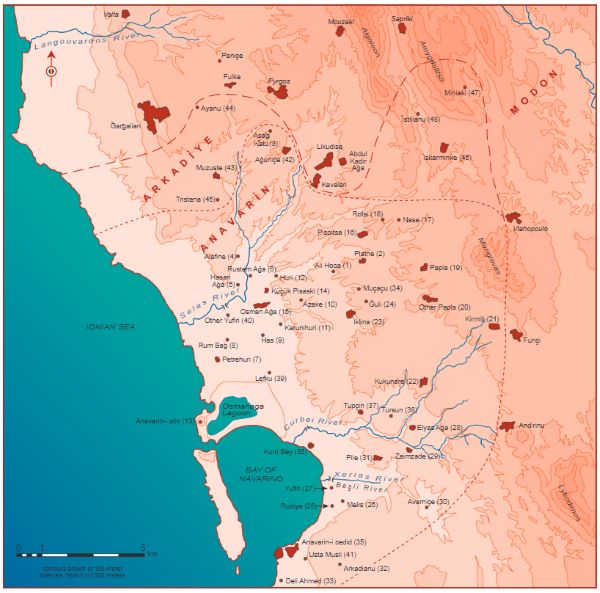
The mission of the scribes was to describe the fortresses, as well as villages (karyes), small estates occupied by sharecroppers (çiftliks), abandoned estates (mazra’as), vineyards, and trees.21 The boundaries of each of forty-nine rural properties are recorded as a series of toponyms, written diagonally, sloping upward from left to right at the end of each entry. We were able to locate 86 percent of them, and since in many instances, it was also possible to determine the placement of the boundaries, we succeeded in making a map where the Ottomans had supplied none (see map 2).
Twenty-four of the forty-nine properties in the Pylos district were registered as çiftliks, with taxes assigned as a form of salary to Ottoman cavalrymen or state officials.22 Sixteen of these were populated in 1716, and the majority of non-Muslims in the area lived in them. Other estates (mazra’as) in the lowlands north of the Bay of Navarino and near New Navarino were uninhabited, and the cadaster’s text hints that there had been an overall decline in the extent of arable cultivation in the district. Such a state of affairs may partly have resulted from Venice’s war of conquest in 1685. The situation may also have been aggravated by the Venetian retreat in 1715, when some of its subjects deserted their lands and left the Peloponnese behind.
The first part of the entry for each çiftlik consists of a description of goods not personally owned by the sharecroppers, being state property from which the beneficiary of the çiftlik profited. Real property is listed first: houses, towers, and furniture. Presses and mills follow, sometimes with comments on their condition or whether they were used seasonally or all year. Fruit trees and olive trees were counted individually. Then the extent of arable land was recorded.
The second part of each entry lists all Christian males living in the çiftlik and their personal property: grain fields, real estate, livestock, and beehives. Finally, the cadaster tabulated the revenue to be collected from the estate for the benefit of the state and its designates.
Ottoman Pylos, though not a major commercial center, was integrated into a broader Mediterranean economy. Our cadaster of 1716 lists olives as exported. (Pylos today is in the heart of the area producing Kalamata olives for market.) By the beginning of the nineteenth century, other cash crops had been added. François Pouqueville, Napoleon Bonaparte’s consul at Ioannina, mentions grain, vermilion, maize, cheese, wool, silk, tobacco leaves, oil, and goat hides.23 British traveler and spy Captain William Leake speaks of “six or seven hundred barrels of oil in good years, some vermilion, tobacco, and goat-skins.”24
From the Ottoman documents, it is clear that the sharecropper system encouraged small-scale, dispersed estates within a settlement pattern dominated by towns where the majority of the population was gathered. It did so in the following ways:
- Sharecroppers had limited mobility and were tied to estates.
- Extensive property belonging to the state needed to be guarded.
- State land could not be divided by partible inheritance.
Such a system ensured that the pattern survived, despite disruptions provoked by acts of war and informal violence. For Ottoman Pylos, as for Kea, social and political factors are key to understanding nucleation and dispersion of settlement. On Kea, where there was no direct control by the Ottoman state, it became possible for a small farmer to amass contiguous parcels of land only after the Greek Revolution of 1821. Although partible inheritance subsequently did operate to fragment an individual’s holdings, out-migration after World War I held the division of land in check. In Pylos, sharecropping served to hold many cultivators close to their fields in Ottoman times.
In the cases of Kea and Pylos, personal agency, or lack thereof, is key to understanding residential dispersion. On Kea, as in early Ohio, small farmers embedded in a market economy chose to move into the countryside only when it was worth sacrificing the benefits of living in a centralized community. In Pylos, the Ottoman system of benefices bound small farmers to the land as sharecroppers in çiftliks. Their choices were limited.
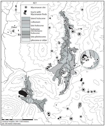
The Ottoman case studies can, I think, help us to understand patterns of settlement in the much more distant past—even in Early Mycenaean times, when intensive survey has documented a virtual explosion in the number and variety of archaeological sites, not only at Pylos. At Nemea, for example, our intensive surface survey found Early Mycenaean pottery at some twenty-five sites, all of them, with the exception of the village at Tsoungiza, very small (see map 3). Some years ago, John Cherry and I argued that this striking expansion of settlement in the Early Mycenaean period reflected efforts by the elite of Mycenae to bring more land under cultivation by improving drainage of the Nemea valley.25
Neither at Nemea nor at Pylos do we have written sources that might explain the nature of the organization of agricultural production in the Early Mycenaean period. Explanations can only be hypothetical, but it seems reasonable to imagine that, as at Nemea, at Pylos too the proliferation of small sites reflects a desire to cultivate more land. Since the completion of our intensive surface survey in the 1990s, a similar survey in an area south of the Palace of Nestor, focused on a large prehistoric settlement near the modern village of Iklaina, has yielded similar results. Iklaina was probably the district capital known as *a-pu2 in Linear B tablets of the thirteenth century B.C.26
Details of Mycenaean agriculture are imperfectly known, but there is broad agreement on many points. John Killen has written that “there is a good deal of evidence to suggest that, just as palaces and temples in the Near East were often significant owners of land, so the central institutions in the Mycenaean world had an effective control over—even if they did not technically own—substantial tracts of the arable [land].”27 Thomas Palaima reports an opinio communis among scholars that there was a “system of landholding, rather than landowning,” according to which a parcel of land, an onāton, would be allotted to an individual according to his status in return for benefits rendered to the state.
Palaima underscores the potential for a system of this sort to increase productivity by bringing more land under cultivation, and there are striking similarities between it and the Ottoman çiftlik. Land is measured in seed grain. In addition, just as the Ottoman documents discriminate between mazra’as and çiftliks, so the Linear B documents distinguish between land under cultivation and land that has the potential to be cultivated.
The hierarchical pattern of settlement that characterizes the Late Bronze Age at Pylos was already in place by the Early Mycenaean period. Was it not then that the elite of Pylos first established the system by which they profited from the agricultural labor of others? We may be witnessing in the Early Mycenaean expansion of small settlements the initial implementation of a system of sharecropping. Palaima, without adducing archaeological evidence, in fact suggested that some of “the structures and methods of mobilizing and controlling labor that we can detect in the Linear B records must have pre-existed the imposition or insertion of the palatial system and then been adapted to new conditions and ways of operating.”28
What would have been the source of the agricultural land controlled by the elite? Who would have worked land granted as a benefice? In the Mycenaean case, as in the Ottoman, we may doubt that the beneficiary of a prebend worked an onāton with his own hands or would have lived on a farmstead distant from centers of power. The settlement around the later Palace of Nestor was already the focus of Early Mycenaean power and doubtless the place where the elite would have congregated.
It seems most likely that, as the community of Pylos extended its control over western Messenia, conquests and acquisitions would have yielded opportunities for the confiscation of land.29 Given the warrior ideology emphasized in Early Mycenaean art and burial practices, this expansion likely resulted as much from the stick as the carrot—and frequently in the face of rival Early Mycenaean centers, such as Iklaina, which had ambitions similar to those of Pylos. Confiscated land could be assigned as benefices and cultivated by land-poor or landless retainers. Rivals to Pylos probably also pursued this same strategy.
A system of benefices would have promoted residence on the land. It would have created circumstances advantageous for small rural settlements to exist and the possibility to extensify and intensify agricultural production, through the integration of arable cultivation and animal husbandry—as happened on Kea in the nineteenth century A.D. The establishment of benefices would also have encouraged the maintenance of small rural estates by restricting the transfer of land through dowry, a force that in other times and places worked against dispersed patterns of settlement within systems grounded in private landownership. The three-tier settlement hierarchy at Pylos had, in fact, a remarkable longevity, lasting until the final collapse of the palatial system ca. 1180 B.C. The dissolution of this pattern, contemporary with the demise of the palaces, in itself suggests the embeddedness of the onāton landholding regime within the Mycenaean political system.
Endnotes
- Balta, Ottoman Studies and Archives.
- Even an interest in the Byzantine Empire was slow to take hold. Athanassopoulos, “Byzantine Monuments.”
- Miller, Latins in the Levant.
- Zarinebaf, Bennet, and Davis, Historical and Economic Geography.
- The Gennadius Library, built in the 1920s to house the collection of John Gennadius, Greek diplomat and bibliophile, is one of the premier research centers in Europe, https://www.ascsa.edu.gr/research/gennadius-library.
- “Greece: The Bay of Navarino. Antient Pylos” (1823).
- MacKay, “Evliya Çelebi’s Account of Anavarin,” 217.
- Cherry, Davis, and Mantzourani, Landscape Archaeology.
- Whitelaw, “Recent Rural Settlement.”
- By “gray literature,” I mean books and articles written in Greek and intended for a nonacademic readership.
- Manthos, Αρχαιολογία της Νήσου Κέας.
- Davis, “Mediterranean Rural Archaeology.”
- Davis and Davies, “Introduction.”
- The Ottomanist and student of landscape archaeology Thurstan Robinson travelled to Istanbul on behalf of our project, where he examined documents in the Prime Minister’s Ottoman Archives. More recent studies by Mohammad Shariat-Panahi (Ottoman Corinthia) and Georgios Liakopoulos (Early Ottoman Peloponnese) have added much to the picture.
- Longnon and Topping, Documents sur le régime des terres; Davies, “Administration and Settlement in Venetian Navarino.”
- Bennet, Davis, and Zarinebaf-Shahr, “William Gell’s Itinerary.”
- Gell, Narrative of a Journey, 59–60.
- Sutton, “A Temple Worth Seeing.”
- Kiel, “Rise and Decline,” 317.
- A book resulting from a decade-long collaboration between Fariba Zarinebaf, an Ottomanist; John Bennet, an archaeologist and Linear B expert; and me: Historical and Economic Geography.
- In general Ottoman usage, a mazra’a is an agricultural estate capable of supporting a settlement, but which has been abandoned.
- Balta, Population and Agricultural Production, 19. Such small holdings were entirely different from the much larger estates in northern Greece discussed by Halstead in “Surplus and Sharecroppers.”
- Pouqueville, Voyage dans la Grèce.
- Leake, Travels in the Morea I, 401.
- Cherry and Davis, “Under the Sceptre.”
- Cosmopoulos, Political Geography of a Mycenaean District.
- Killen, “Mycenaean Economy,” 162–63.
- Palaima, “The Mycenaean Mobilization of Labor.”
- Nakassis, Individuals and Society, 181–83, with references.
Chapter 3 (29-42) from A Greek State in Formation: The Origins of Civilization in Mycenaean Pylos, by Jack L. Davis (University of California Press, 05.03.2022), republished by OAPEN under the terms of a Creative Commons Attribution-NonCommercial-NoDerivs 2.0 Generic license.
About the Author